You are here: Home > Network List > TA - USArray Transportable Network (new EarthScope stations) Stations List
> Station 958A Wauchula, FL, USA > Earthquake Result Viewer
958A Wauchula, FL, USA - Earthquake Result Viewer
| Earthquake location: |
Sea Of Okhotsk |
| Earthquake latitude/longitude: |
52.2/151.4 |
| Earthquake time(UTC): |
2013/05/24 (144) 14:56:31 GMT |
| Earthquake Depth: |
624 km |
| Earthquake Magnitude: |
6.7 MW, 6.7 MB, 6.7 MW |
| Earthquake Catalog/Contributor: |
NEIC PDE/NEIC PDE-W |
|
| Network: |
TA USArray Transportable Network (new EarthScope stations) |
| Station: |
958A Wauchula, FL, USA |
| Lat/Lon: |
27.59 N/81.75 W |
| Elevation: |
30 m |
|
| Distance: |
87.9 deg |
| Az: |
45.33 deg |
| Baz: |
330.478 deg |
| Ray Param: |
0.04167742 |
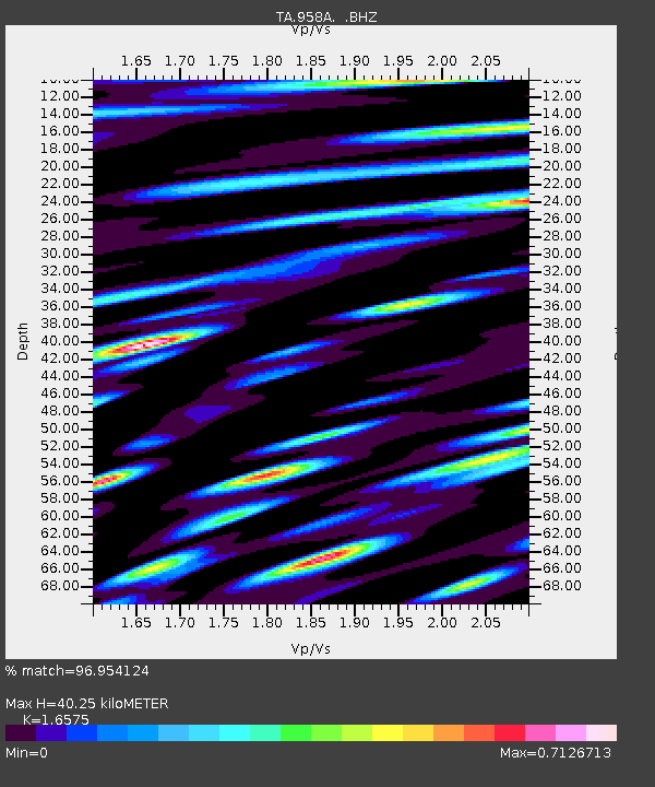
| Estimated Moho Depth: |
40.25 km |
| Estimated Crust Vp/Vs: |
1.66 |
| Assumed Crust Vp: |
6.347 km/s |
| Estimated Crust Vs: |
3.829 km/s |
| Estimated Crust Poisson's Ratio: |
0.21 |
|
| Radial Match: |
96.954124 % |
| Radial Bump: |
400 |
| Transverse Match: |
91.14538 % |
| Transverse Bump: |
400 |
| SOD ConfigId: |
512894 |
| Insert Time: |
2013-09-14 19:25:57.232 +0000 |
| GWidth: |
2.5 |
| Max Bumps: |
400 |
| Tol: |
0.001 |
|
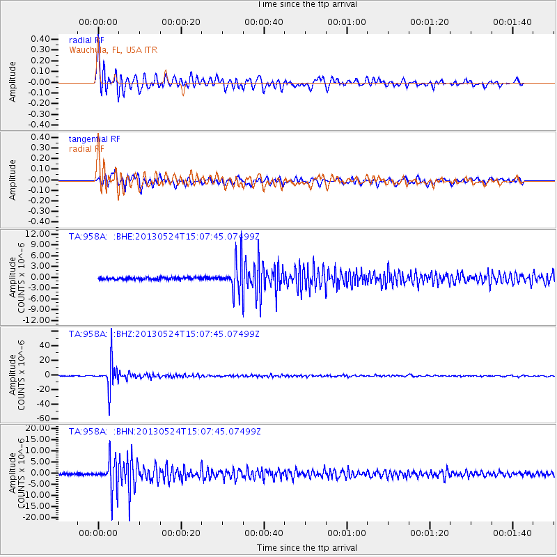
Signal To Noise
| Channel | StoN | STA | LTA |
| TA:958A: :BHZ:20130524T15:07:45.07499Z | 61.178535 | 1.8343375E-5 | 2.9983352E-7 |
| TA:958A: :BHN:20130524T15:07:45.07499Z | 21.240477 | 6.8978006E-6 | 3.2474793E-7 |
| TA:958A: :BHE:20130524T15:07:45.07499Z | 13.591794 | 4.146421E-6 | 3.0506794E-7 |
| Arrivals |
| Ps | 4.3 SECOND |
| PpPs | 16 SECOND |
| PsPs/PpSs | 21 SECOND |


