You are here: Home > Network List > TA - USArray Transportable Network (new EarthScope stations) Stations List
> Station D41A Chassel, MI, USA > Earthquake Result Viewer
D41A Chassel, MI, USA - Earthquake Result Viewer
| Earthquake location: |
Sea Of Okhotsk |
| Earthquake latitude/longitude: |
52.2/151.4 |
| Earthquake time(UTC): |
2013/05/24 (144) 14:56:31 GMT |
| Earthquake Depth: |
624 km |
| Earthquake Magnitude: |
6.7 MW, 6.7 MB, 6.7 MW |
| Earthquake Catalog/Contributor: |
NEIC PDE/NEIC PDE-W |
|
| Network: |
TA USArray Transportable Network (new EarthScope stations) |
| Station: |
D41A Chassel, MI, USA |
| Lat/Lon: |
47.06 N/88.57 W |
| Elevation: |
271 m |
|
| Distance: |
68.6 deg |
| Az: |
39.501 deg |
| Baz: |
325.097 deg |
| Ray Param: |
0.053963218 |
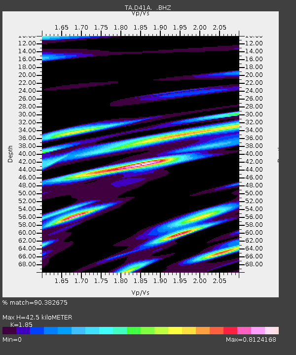
| Estimated Moho Depth: |
42.5 km |
| Estimated Crust Vp/Vs: |
1.85 |
| Assumed Crust Vp: |
6.467 km/s |
| Estimated Crust Vs: |
3.495 km/s |
| Estimated Crust Poisson's Ratio: |
0.29 |
|
| Radial Match: |
90.382675 % |
| Radial Bump: |
400 |
| Transverse Match: |
84.99931 % |
| Transverse Bump: |
400 |
| SOD ConfigId: |
512894 |
| Insert Time: |
2013-09-14 19:26:21.876 +0000 |
| GWidth: |
2.5 |
| Max Bumps: |
400 |
| Tol: |
0.001 |
|
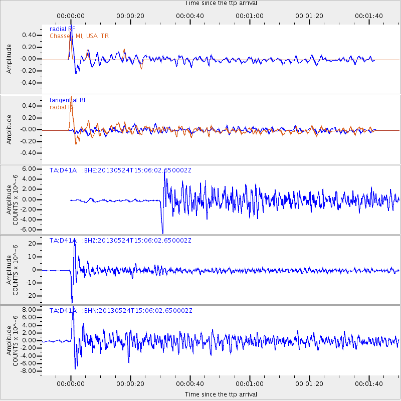
Signal To Noise
| Channel | StoN | STA | LTA |
| TA:D41A: :BHZ:20130524T15:06:02.650002Z | 60.862026 | 9.937121E-6 | 1.6327292E-7 |
| TA:D41A: :BHN:20130524T15:06:02.650002Z | 18.219944 | 3.6336799E-6 | 1.994342E-7 |
| TA:D41A: :BHE:20130524T15:06:02.650002Z | 16.308516 | 2.599971E-6 | 1.5942413E-7 |
| Arrivals |
| Ps | 5.8 SECOND |
| PpPs | 18 SECOND |
| PsPs/PpSs | 24 SECOND |


