You are here: Home > Network List > TA - USArray Transportable Network (new EarthScope stations) Stations List
> Station E38A The Farm, Brule, WI, USA > Earthquake Result Viewer
E38A The Farm, Brule, WI, USA - Earthquake Result Viewer
| Earthquake location: |
Sea Of Okhotsk |
| Earthquake latitude/longitude: |
52.2/151.4 |
| Earthquake time(UTC): |
2013/05/24 (144) 14:56:31 GMT |
| Earthquake Depth: |
624 km |
| Earthquake Magnitude: |
6.7 MW, 6.7 MB, 6.7 MW |
| Earthquake Catalog/Contributor: |
NEIC PDE/NEIC PDE-W |
|
| Network: |
TA USArray Transportable Network (new EarthScope stations) |
| Station: |
E38A The Farm, Brule, WI, USA |
| Lat/Lon: |
46.61 N/91.55 W |
| Elevation: |
341 m |
|
| Distance: |
67.7 deg |
| Az: |
41.584 deg |
| Baz: |
323.698 deg |
| Ray Param: |
0.05447901 |
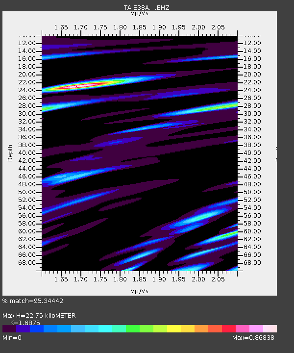
| Estimated Moho Depth: |
22.75 km |
| Estimated Crust Vp/Vs: |
1.69 |
| Assumed Crust Vp: |
6.467 km/s |
| Estimated Crust Vs: |
3.832 km/s |
| Estimated Crust Poisson's Ratio: |
0.23 |
|
| Radial Match: |
95.34442 % |
| Radial Bump: |
400 |
| Transverse Match: |
93.194084 % |
| Transverse Bump: |
400 |
| SOD ConfigId: |
512894 |
| Insert Time: |
2013-09-14 19:26:48.539 +0000 |
| GWidth: |
2.5 |
| Max Bumps: |
400 |
| Tol: |
0.001 |
|

Signal To Noise
| Channel | StoN | STA | LTA |
| TA:E38A: :BHZ:20130524T15:05:57.699014Z | 79.9781 | 1.454516E-5 | 1.8186428E-7 |
| TA:E38A: :BHN:20130524T15:05:57.699014Z | 38.58306 | 5.4158877E-6 | 1.4036958E-7 |
| TA:E38A: :BHE:20130524T15:05:57.699014Z | 30.064968 | 4.793792E-6 | 1.5944777E-7 |
| Arrivals |
| Ps | 2.5 SECOND |
| PpPs | 9.1 SECOND |
| PsPs/PpSs | 12 SECOND |


