You are here: Home > Network List > TA - USArray Transportable Network (new EarthScope stations) Stations List
> Station F38A Pierce - Schroeder Farm, Trego, WI, USA > Earthquake Result Viewer
F38A Pierce - Schroeder Farm, Trego, WI, USA - Earthquake Result Viewer

| Earthquake location: |
Sea Of Okhotsk |
| Earthquake latitude/longitude: |
52.2/151.4 |
| Earthquake time(UTC): |
2013/05/24 (144) 14:56:31 GMT |
| Earthquake Depth: |
624 km |
| Earthquake Magnitude: |
6.7 MW, 6.7 MB, 6.7 MW |
| Earthquake Catalog/Contributor: |
NEIC PDE/NEIC PDE-W |
|
| Network: |
TA USArray Transportable Network (new EarthScope stations) |
| Station: |
F38A Pierce - Schroeder Farm, Trego, WI, USA |
| Lat/Lon: |
45.96 N/91.88 W |
| Elevation: |
321 m |
|
| Distance: |
68.1 deg |
| Az: |
42.192 deg |
| Baz: |
323.694 deg |
| Ray Param: |
0.054238647 |
| Estimated Moho Depth: |
56.5 km |
| Estimated Crust Vp/Vs: |
1.65 |
| Assumed Crust Vp: |
6.571 km/s |
| Estimated Crust Vs: |
3.976 km/s |
| Estimated Crust Poisson's Ratio: |
0.21 |
|
| Radial Match: |
96.034935 % |
| Radial Bump: |
273 |
| Transverse Match: |
92.96266 % |
| Transverse Bump: |
400 |
| SOD ConfigId: |
512894 |
| Insert Time: |
2013-09-14 19:27:40.264 +0000 |
| GWidth: |
2.5 |
| Max Bumps: |
400 |
| Tol: |
0.001 |
|
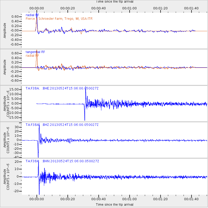
Signal To Noise
| Channel | StoN | STA | LTA |
| TA:F38A: :BHZ:20130524T15:06:00.050027Z | 108.42363 | 1.327747E-5 | 1.224592E-7 |
| TA:F38A: :BHN:20130524T15:06:00.050027Z | 42.642673 | 6.8758536E-6 | 1.6124349E-7 |
| TA:F38A: :BHE:20130524T15:06:00.050027Z | 33.200134 | 5.356173E-6 | 1.6132987E-7 |
| Arrivals |
| Ps | 5.8 SECOND |
| PpPs | 22 SECOND |
| PsPs/PpSs | 28 SECOND |


