You are here: Home > Network List > TA - USArray Transportable Network (new EarthScope stations) Stations List
> Station F40A Park Falls, WI, USA > Earthquake Result Viewer
F40A Park Falls, WI, USA - Earthquake Result Viewer
| Earthquake location: |
Sea Of Okhotsk |
| Earthquake latitude/longitude: |
52.2/151.4 |
| Earthquake time(UTC): |
2013/05/24 (144) 14:56:31 GMT |
| Earthquake Depth: |
624 km |
| Earthquake Magnitude: |
6.7 MW, 6.7 MB, 6.7 MW |
| Earthquake Catalog/Contributor: |
NEIC PDE/NEIC PDE-W |
|
| Network: |
TA USArray Transportable Network (new EarthScope stations) |
| Station: |
F40A Park Falls, WI, USA |
| Lat/Lon: |
45.92 N/90.12 W |
| Elevation: |
486 m |
|
| Distance: |
68.9 deg |
| Az: |
41.15 deg |
| Baz: |
324.57 deg |
| Ray Param: |
0.0537647 |
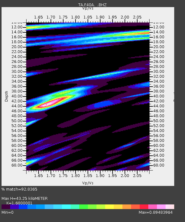
| Estimated Moho Depth: |
43.25 km |
| Estimated Crust Vp/Vs: |
1.68 |
| Assumed Crust Vp: |
6.571 km/s |
| Estimated Crust Vs: |
3.911 km/s |
| Estimated Crust Poisson's Ratio: |
0.23 |
|
| Radial Match: |
92.8365 % |
| Radial Bump: |
400 |
| Transverse Match: |
89.19134 % |
| Transverse Bump: |
400 |
| SOD ConfigId: |
512894 |
| Insert Time: |
2013-09-14 19:27:45.001 +0000 |
| GWidth: |
2.5 |
| Max Bumps: |
400 |
| Tol: |
0.001 |
|

Signal To Noise
| Channel | StoN | STA | LTA |
| TA:F40A: :BHZ:20130524T15:06:04.525002Z | 65.639496 | 9.2956925E-6 | 1.4161736E-7 |
| TA:F40A: :BHN:20130524T15:06:04.525002Z | 15.317339 | 2.9161652E-6 | 1.9038329E-7 |
| TA:F40A: :BHE:20130524T15:06:04.525002Z | 22.990473 | 2.0680357E-6 | 8.9951854E-8 |
| Arrivals |
| Ps | 4.7 SECOND |
| PpPs | 17 SECOND |
| PsPs/PpSs | 22 SECOND |


