You are here: Home > Network List > TA - USArray Transportable Network (new EarthScope stations) Stations List
> Station F43A Flat Rock, Escanaba, MI, USA > Earthquake Result Viewer
F43A Flat Rock, Escanaba, MI, USA - Earthquake Result Viewer
| Earthquake location: |
Sea Of Okhotsk |
| Earthquake latitude/longitude: |
52.2/151.4 |
| Earthquake time(UTC): |
2013/05/24 (144) 14:56:31 GMT |
| Earthquake Depth: |
624 km |
| Earthquake Magnitude: |
6.7 MW, 6.7 MB, 6.7 MW |
| Earthquake Catalog/Contributor: |
NEIC PDE/NEIC PDE-W |
|
| Network: |
TA USArray Transportable Network (new EarthScope stations) |
| Station: |
F43A Flat Rock, Escanaba, MI, USA |
| Lat/Lon: |
45.83 N/87.17 W |
| Elevation: |
233 m |
|
| Distance: |
70.1 deg |
| Az: |
39.393 deg |
| Baz: |
326.067 deg |
| Ray Param: |
0.05298902 |
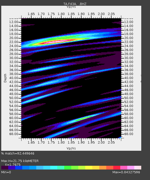
| Estimated Moho Depth: |
21.75 km |
| Estimated Crust Vp/Vs: |
1.77 |
| Assumed Crust Vp: |
6.53 km/s |
| Estimated Crust Vs: |
3.695 km/s |
| Estimated Crust Poisson's Ratio: |
0.26 |
|
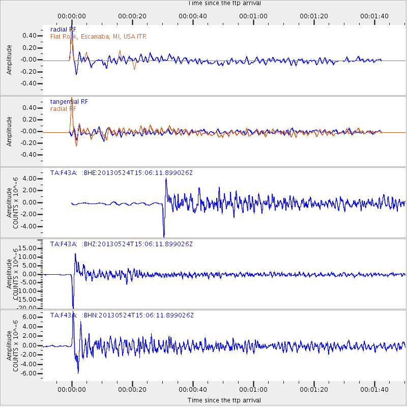
| Radial Match: |
92.449646 % |
| Radial Bump: |
400 |
| Transverse Match: |
86.20473 % |
| Transverse Bump: |
400 |
| SOD ConfigId: |
512894 |
| Insert Time: |
2013-09-14 19:27:52.627 +0000 |
| GWidth: |
2.5 |
| Max Bumps: |
400 |
| Tol: |
0.001 |
|
Signal To Noise
| Channel | StoN | STA | LTA |
| TA:F43A: :BHZ:20130524T15:06:11.899026Z | 38.162437 | 6.592342E-6 | 1.7274425E-7 |
| TA:F43A: :BHN:20130524T15:06:11.899026Z | 22.731186 | 2.9037822E-6 | 1.2774443E-7 |
| TA:F43A: :BHE:20130524T15:06:11.899026Z | 15.361225 | 1.9427262E-6 | 1.2646947E-7 |
| Arrivals |
| Ps | 2.6 SECOND |
| PpPs | 8.9 SECOND |
| PsPs/PpSs | 12 SECOND |


