You are here: Home > Network List > TA - USArray Transportable Network (new EarthScope stations) Stations List
> Station F45A CMU Biological Station, Beaver Island, MI, USA > Earthquake Result Viewer
F45A CMU Biological Station, Beaver Island, MI, USA - Earthquake Result Viewer

| Earthquake location: |
Sea Of Okhotsk |
| Earthquake latitude/longitude: |
52.2/151.4 |
| Earthquake time(UTC): |
2013/05/24 (144) 14:56:31 GMT |
| Earthquake Depth: |
624 km |
| Earthquake Magnitude: |
6.7 MW, 6.7 MB, 6.7 MW |
| Earthquake Catalog/Contributor: |
NEIC PDE/NEIC PDE-W |
|
| Network: |
TA USArray Transportable Network (new EarthScope stations) |
| Station: |
F45A CMU Biological Station, Beaver Island, MI, USA |
| Lat/Lon: |
45.68 N/85.52 W |
| Elevation: |
173 m |
|
| Distance: |
70.9 deg |
| Az: |
38.455 deg |
| Baz: |
326.935 deg |
| Ray Param: |
0.052505687 |
| Estimated Moho Depth: |
57.0 km |
| Estimated Crust Vp/Vs: |
1.98 |
| Assumed Crust Vp: |
6.483 km/s |
| Estimated Crust Vs: |
3.278 km/s |
| Estimated Crust Poisson's Ratio: |
0.33 |
|
| Radial Match: |
93.12398 % |
| Radial Bump: |
400 |
| Transverse Match: |
90.35276 % |
| Transverse Bump: |
400 |
| SOD ConfigId: |
512894 |
| Insert Time: |
2013-09-14 19:27:57.371 +0000 |
| GWidth: |
2.5 |
| Max Bumps: |
400 |
| Tol: |
0.001 |
|
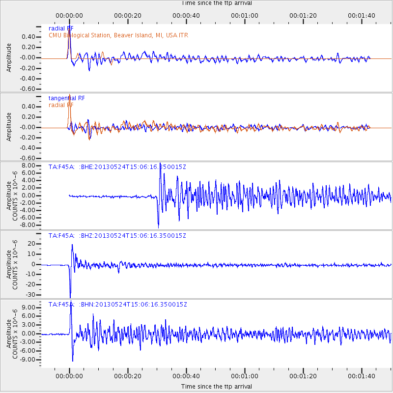
Signal To Noise
| Channel | StoN | STA | LTA |
| TA:F45A: :BHZ:20130524T15:06:16.350015Z | 68.874886 | 9.745413E-6 | 1.4149443E-7 |
| TA:F45A: :BHN:20130524T15:06:16.350015Z | 23.269407 | 3.8263065E-6 | 1.6443506E-7 |
| TA:F45A: :BHE:20130524T15:06:16.350015Z | 28.91388 | 3.568766E-6 | 1.2342743E-7 |
| Arrivals |
| Ps | 8.9 SECOND |
| PpPs | 25 SECOND |
| PsPs/PpSs | 34 SECOND |


