You are here: Home > Network List > TA - USArray Transportable Network (new EarthScope stations) Stations List
> Station F46A Macinaw City Comets, Mackinaw City, MI, USA > Earthquake Result Viewer
F46A Macinaw City Comets, Mackinaw City, MI, USA - Earthquake Result Viewer

| Earthquake location: |
Sea Of Okhotsk |
| Earthquake latitude/longitude: |
52.2/151.4 |
| Earthquake time(UTC): |
2013/05/24 (144) 14:56:31 GMT |
| Earthquake Depth: |
624 km |
| Earthquake Magnitude: |
6.7 MW, 6.7 MB, 6.7 MW |
| Earthquake Catalog/Contributor: |
NEIC PDE/NEIC PDE-W |
|
| Network: |
TA USArray Transportable Network (new EarthScope stations) |
| Station: |
F46A Macinaw City Comets, Mackinaw City, MI, USA |
| Lat/Lon: |
45.77 N/84.76 W |
| Elevation: |
198 m |
|
| Distance: |
71.1 deg |
| Az: |
37.933 deg |
| Baz: |
327.305 deg |
| Ray Param: |
0.0523706 |
| Estimated Moho Depth: |
14.5 km |
| Estimated Crust Vp/Vs: |
1.80 |
| Assumed Crust Vp: |
6.483 km/s |
| Estimated Crust Vs: |
3.606 km/s |
| Estimated Crust Poisson's Ratio: |
0.28 |
|
| Radial Match: |
96.41221 % |
| Radial Bump: |
400 |
| Transverse Match: |
92.37521 % |
| Transverse Bump: |
400 |
| SOD ConfigId: |
512894 |
| Insert Time: |
2013-09-14 19:28:00.203 +0000 |
| GWidth: |
2.5 |
| Max Bumps: |
400 |
| Tol: |
0.001 |
|
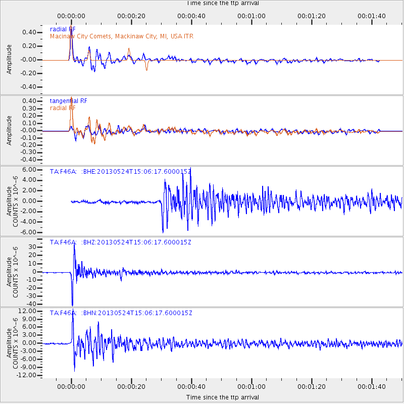
Signal To Noise
| Channel | StoN | STA | LTA |
| TA:F46A: :BHZ:20130524T15:06:17.600015Z | 89.79663 | 1.4047245E-5 | 1.5643398E-7 |
| TA:F46A: :BHN:20130524T15:06:17.600015Z | 29.430964 | 4.2708066E-6 | 1.451127E-7 |
| TA:F46A: :BHE:20130524T15:06:17.600015Z | 17.36655 | 2.460966E-6 | 1.4170725E-7 |
| Arrivals |
| Ps | 1.8 SECOND |
| PpPs | 6.1 SECOND |
| PsPs/PpSs | 7.9 SECOND |


