You are here: Home > Network List > TA - USArray Transportable Network (new EarthScope stations) Stations List
> Station G55A Calabogie, ON, CAN > Earthquake Result Viewer
G55A Calabogie, ON, CAN - Earthquake Result Viewer

| Earthquake location: |
Sea Of Okhotsk |
| Earthquake latitude/longitude: |
52.2/151.4 |
| Earthquake time(UTC): |
2013/05/24 (144) 14:56:31 GMT |
| Earthquake Depth: |
624 km |
| Earthquake Magnitude: |
6.7 MW, 6.7 MB, 6.7 MW |
| Earthquake Catalog/Contributor: |
NEIC PDE/NEIC PDE-W |
|
| Network: |
TA USArray Transportable Network (new EarthScope stations) |
| Station: |
G55A Calabogie, ON, CAN |
| Lat/Lon: |
45.25 N/76.72 W |
| Elevation: |
228 m |
|
| Distance: |
74.4 deg |
| Az: |
33.114 deg |
| Baz: |
331.598 deg |
| Ray Param: |
0.050259475 |
| Estimated Moho Depth: |
39.25 km |
| Estimated Crust Vp/Vs: |
1.78 |
| Assumed Crust Vp: |
6.577 km/s |
| Estimated Crust Vs: |
3.7 km/s |
| Estimated Crust Poisson's Ratio: |
0.27 |
|
| Radial Match: |
95.26621 % |
| Radial Bump: |
391 |
| Transverse Match: |
85.81069 % |
| Transverse Bump: |
400 |
| SOD ConfigId: |
512894 |
| Insert Time: |
2013-09-14 19:28:43.973 +0000 |
| GWidth: |
2.5 |
| Max Bumps: |
400 |
| Tol: |
0.001 |
|
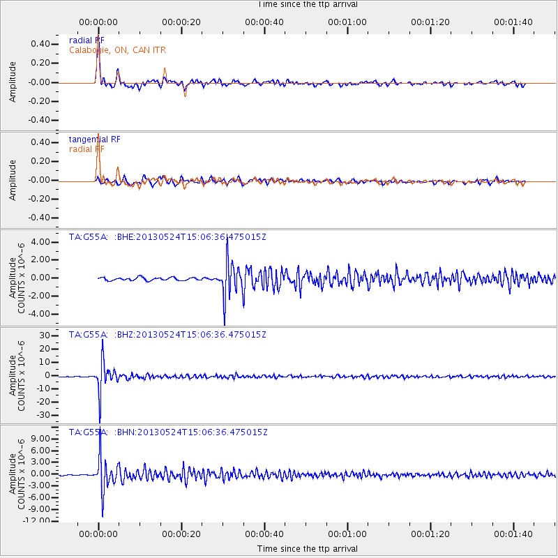
Signal To Noise
| Channel | StoN | STA | LTA |
| TA:G55A: :BHZ:20130524T15:06:36.475015Z | 47.2816 | 1.1505887E-5 | 2.433481E-7 |
| TA:G55A: :BHN:20130524T15:06:36.475015Z | 34.38256 | 4.318858E-6 | 1.2561188E-7 |
| TA:G55A: :BHE:20130524T15:06:36.475015Z | 12.032197 | 1.9762774E-6 | 1.6424909E-7 |
| Arrivals |
| Ps | 4.8 SECOND |
| PpPs | 16 SECOND |
| PsPs/PpSs | 21 SECOND |


