You are here: Home > Network List > TA - USArray Transportable Network (new EarthScope stations) Stations List
> Station H45A Beulah, MI, USA > Earthquake Result Viewer
H45A Beulah, MI, USA - Earthquake Result Viewer
| Earthquake location: |
Sea Of Okhotsk |
| Earthquake latitude/longitude: |
52.2/151.4 |
| Earthquake time(UTC): |
2013/05/24 (144) 14:56:31 GMT |
| Earthquake Depth: |
624 km |
| Earthquake Magnitude: |
6.7 MW, 6.7 MB, 6.7 MW |
| Earthquake Catalog/Contributor: |
NEIC PDE/NEIC PDE-W |
|
| Network: |
TA USArray Transportable Network (new EarthScope stations) |
| Station: |
H45A Beulah, MI, USA |
| Lat/Lon: |
44.62 N/86.04 W |
| Elevation: |
242 m |
|
| Distance: |
71.6 deg |
| Az: |
39.398 deg |
| Baz: |
326.865 deg |
| Ray Param: |
0.052070234 |
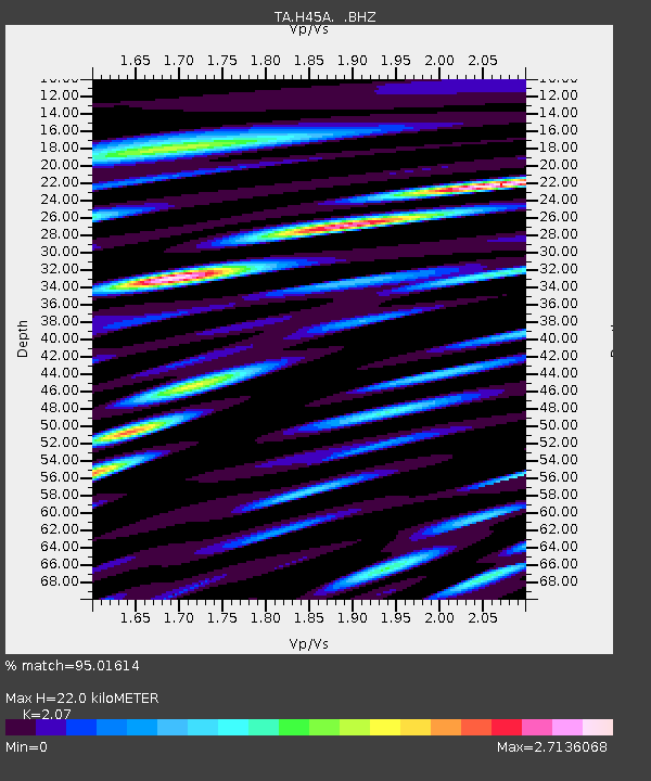
| Estimated Moho Depth: |
22.0 km |
| Estimated Crust Vp/Vs: |
2.07 |
| Assumed Crust Vp: |
6.53 km/s |
| Estimated Crust Vs: |
3.155 km/s |
| Estimated Crust Poisson's Ratio: |
0.35 |
|
| Radial Match: |
95.01614 % |
| Radial Bump: |
400 |
| Transverse Match: |
90.05253 % |
| Transverse Bump: |
400 |
| SOD ConfigId: |
512894 |
| Insert Time: |
2013-09-14 19:29:08.353 +0000 |
| GWidth: |
2.5 |
| Max Bumps: |
400 |
| Tol: |
0.001 |
|

Signal To Noise
| Channel | StoN | STA | LTA |
| TA:H45A: :BHZ:20130524T15:06:20.32499Z | 63.470604 | 1.139197E-5 | 1.7948419E-7 |
| TA:H45A: :BHN:20130524T15:06:20.32499Z | 26.755928 | 7.3859783E-6 | 2.7605014E-7 |
| TA:H45A: :BHE:20130524T15:06:20.32499Z | 14.0213 | 4.7683197E-6 | 3.4007687E-7 |
| Arrivals |
| Ps | 3.7 SECOND |
| PpPs | 10 SECOND |
| PsPs/PpSs | 14 SECOND |


