You are here: Home > Network List > TA - USArray Transportable Network (new EarthScope stations) Stations List
> Station H56A Elgin, ON, CAN > Earthquake Result Viewer
H56A Elgin, ON, CAN - Earthquake Result Viewer
| Earthquake location: |
Sea Of Okhotsk |
| Earthquake latitude/longitude: |
52.2/151.4 |
| Earthquake time(UTC): |
2013/05/24 (144) 14:56:31 GMT |
| Earthquake Depth: |
624 km |
| Earthquake Magnitude: |
6.7 MW, 6.7 MB, 6.7 MW |
| Earthquake Catalog/Contributor: |
NEIC PDE/NEIC PDE-W |
|
| Network: |
TA USArray Transportable Network (new EarthScope stations) |
| Station: |
H56A Elgin, ON, CAN |
| Lat/Lon: |
44.59 N/76.26 W |
| Elevation: |
137 m |
|
| Distance: |
75.2 deg |
| Az: |
33.14 deg |
| Baz: |
331.928 deg |
| Ray Param: |
0.04978407 |
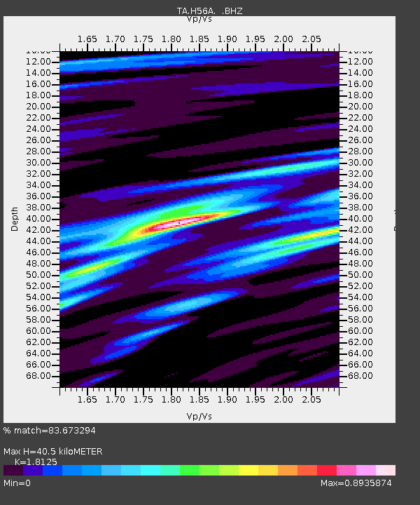
| Estimated Moho Depth: |
40.5 km |
| Estimated Crust Vp/Vs: |
1.81 |
| Assumed Crust Vp: |
6.577 km/s |
| Estimated Crust Vs: |
3.629 km/s |
| Estimated Crust Poisson's Ratio: |
0.28 |
|
| Radial Match: |
83.673294 % |
| Radial Bump: |
400 |
| Transverse Match: |
80.62187 % |
| Transverse Bump: |
400 |
| SOD ConfigId: |
512894 |
| Insert Time: |
2013-09-14 19:29:23.208 +0000 |
| GWidth: |
2.5 |
| Max Bumps: |
400 |
| Tol: |
0.001 |
|

Signal To Noise
| Channel | StoN | STA | LTA |
| TA:H56A: :BHZ:20130524T15:06:40.550027Z | 34.860577 | 8.153188E-6 | 2.3387987E-7 |
| TA:H56A: :BHN:20130524T15:06:40.550027Z | 12.05021 | 3.2336357E-6 | 2.6834684E-7 |
| TA:H56A: :BHE:20130524T15:06:40.550027Z | 9.886632 | 1.5517504E-6 | 1.569544E-7 |
| Arrivals |
| Ps | 5.2 SECOND |
| PpPs | 17 SECOND |
| PsPs/PpSs | 22 SECOND |


