You are here: Home > Network List > TA - USArray Transportable Network (new EarthScope stations) Stations List
> Station I40A Norwalk, WI, USA > Earthquake Result Viewer
I40A Norwalk, WI, USA - Earthquake Result Viewer
| Earthquake location: |
Sea Of Okhotsk |
| Earthquake latitude/longitude: |
52.2/151.4 |
| Earthquake time(UTC): |
2013/05/24 (144) 14:56:31 GMT |
| Earthquake Depth: |
624 km |
| Earthquake Magnitude: |
6.7 MW, 6.7 MB, 6.7 MW |
| Earthquake Catalog/Contributor: |
NEIC PDE/NEIC PDE-W |
|
| Network: |
TA USArray Transportable Network (new EarthScope stations) |
| Station: |
I40A Norwalk, WI, USA |
| Lat/Lon: |
43.89 N/90.62 W |
| Elevation: |
419 m |
|
| Distance: |
70.3 deg |
| Az: |
42.708 deg |
| Baz: |
324.763 deg |
| Ray Param: |
0.052860294 |
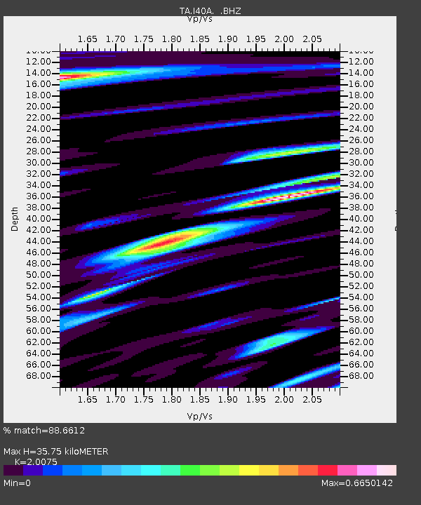
| Estimated Moho Depth: |
35.75 km |
| Estimated Crust Vp/Vs: |
2.01 |
| Assumed Crust Vp: |
6.53 km/s |
| Estimated Crust Vs: |
3.253 km/s |
| Estimated Crust Poisson's Ratio: |
0.33 |
|
| Radial Match: |
88.6612 % |
| Radial Bump: |
400 |
| Transverse Match: |
85.749016 % |
| Transverse Bump: |
400 |
| SOD ConfigId: |
512894 |
| Insert Time: |
2013-09-14 19:29:41.927 +0000 |
| GWidth: |
2.5 |
| Max Bumps: |
400 |
| Tol: |
0.001 |
|

Signal To Noise
| Channel | StoN | STA | LTA |
| TA:I40A: :BHZ:20130524T15:06:13.100015Z | 73.61661 | 8.3191135E-6 | 1.13005925E-7 |
| TA:I40A: :BHN:20130524T15:06:13.100015Z | 25.644913 | 2.850285E-6 | 1.1114427E-7 |
| TA:I40A: :BHE:20130524T15:06:13.100015Z | 24.062078 | 2.41497E-6 | 1.0036415E-7 |
| Arrivals |
| Ps | 5.7 SECOND |
| PpPs | 16 SECOND |
| PsPs/PpSs | 22 SECOND |


