You are here: Home > Network List > TA - USArray Transportable Network (new EarthScope stations) Stations List
> Station K43A Burlington, WI, USA > Earthquake Result Viewer
K43A Burlington, WI, USA - Earthquake Result Viewer
| Earthquake location: |
Sea Of Okhotsk |
| Earthquake latitude/longitude: |
52.2/151.4 |
| Earthquake time(UTC): |
2013/05/24 (144) 14:56:31 GMT |
| Earthquake Depth: |
624 km |
| Earthquake Magnitude: |
6.7 MW, 6.7 MB, 6.7 MW |
| Earthquake Catalog/Contributor: |
NEIC PDE/NEIC PDE-W |
|
| Network: |
TA USArray Transportable Network (new EarthScope stations) |
| Station: |
K43A Burlington, WI, USA |
| Lat/Lon: |
42.70 N/88.33 W |
| Elevation: |
264 m |
|
| Distance: |
72.3 deg |
| Az: |
41.968 deg |
| Baz: |
326.088 deg |
| Ray Param: |
0.051643435 |
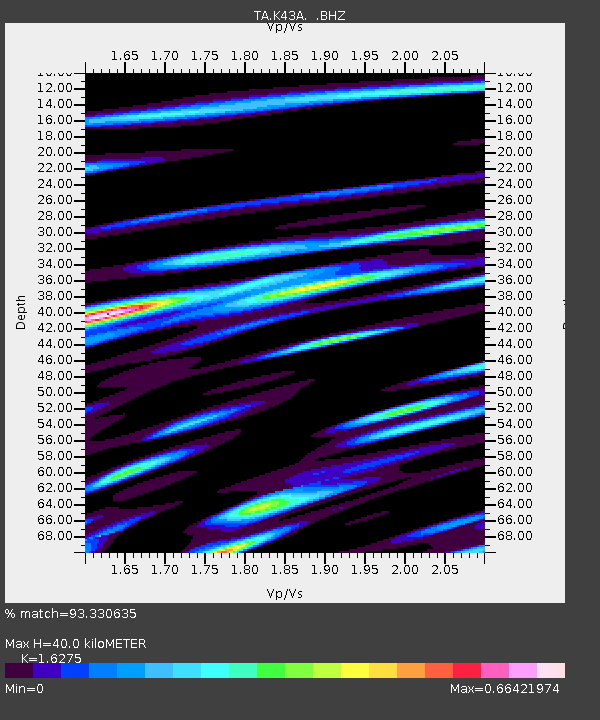
| Estimated Moho Depth: |
40.0 km |
| Estimated Crust Vp/Vs: |
1.63 |
| Assumed Crust Vp: |
6.571 km/s |
| Estimated Crust Vs: |
4.037 km/s |
| Estimated Crust Poisson's Ratio: |
0.20 |
|
| Radial Match: |
93.330635 % |
| Radial Bump: |
400 |
| Transverse Match: |
82.07902 % |
| Transverse Bump: |
400 |
| SOD ConfigId: |
512894 |
| Insert Time: |
2013-09-14 19:31:11.775 +0000 |
| GWidth: |
2.5 |
| Max Bumps: |
400 |
| Tol: |
0.001 |
|

Signal To Noise
| Channel | StoN | STA | LTA |
| TA:K43A: :BHZ:20130524T15:06:24.249978Z | 66.729546 | 1.1305098E-5 | 1.6941668E-7 |
| TA:K43A: :BHN:20130524T15:06:24.249978Z | 28.304468 | 3.3641759E-6 | 1.1885671E-7 |
| TA:K43A: :BHE:20130524T15:06:24.249978Z | 22.496742 | 2.3067014E-6 | 1.02534905E-7 |
| Arrivals |
| Ps | 4.0 SECOND |
| PpPs | 15 SECOND |
| PsPs/PpSs | 19 SECOND |


