You are here: Home > Network List > TA - USArray Transportable Network (new EarthScope stations) Stations List
> Station L42A Oliver, Polo, IL, USA > Earthquake Result Viewer
L42A Oliver, Polo, IL, USA - Earthquake Result Viewer
| Earthquake location: |
Sea Of Okhotsk |
| Earthquake latitude/longitude: |
52.2/151.4 |
| Earthquake time(UTC): |
2013/05/24 (144) 14:56:31 GMT |
| Earthquake Depth: |
624 km |
| Earthquake Magnitude: |
6.7 MW, 6.7 MB, 6.7 MW |
| Earthquake Catalog/Contributor: |
NEIC PDE/NEIC PDE-W |
|
| Network: |
TA USArray Transportable Network (new EarthScope stations) |
| Station: |
L42A Oliver, Polo, IL, USA |
| Lat/Lon: |
42.00 N/89.67 W |
| Elevation: |
257 m |
|
| Distance: |
72.3 deg |
| Az: |
43.24 deg |
| Baz: |
325.579 deg |
| Ray Param: |
0.05162846 |
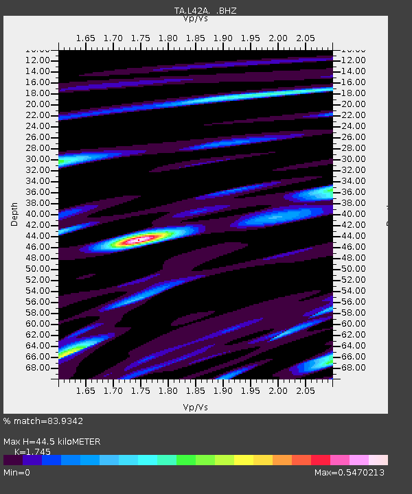
| Estimated Moho Depth: |
44.5 km |
| Estimated Crust Vp/Vs: |
1.75 |
| Assumed Crust Vp: |
6.571 km/s |
| Estimated Crust Vs: |
3.765 km/s |
| Estimated Crust Poisson's Ratio: |
0.26 |
|
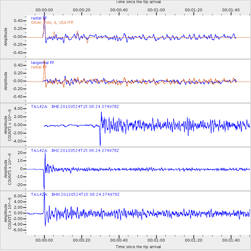
| Radial Match: |
83.9342 % |
| Radial Bump: |
400 |
| Transverse Match: |
71.84155 % |
| Transverse Bump: |
400 |
| SOD ConfigId: |
512894 |
| Insert Time: |
2013-09-14 19:31:55.139 +0000 |
| GWidth: |
2.5 |
| Max Bumps: |
400 |
| Tol: |
0.001 |
|
Signal To Noise
| Channel | StoN | STA | LTA |
| TA:L42A: :BHZ:20130524T15:06:24.374978Z | 44.476254 | 7.193969E-6 | 1.6174853E-7 |
| TA:L42A: :BHN:20130524T15:06:24.374978Z | 15.823832 | 2.3544346E-6 | 1.4879043E-7 |
| TA:L42A: :BHE:20130524T15:06:24.374978Z | 13.386018 | 1.602647E-6 | 1.1972544E-7 |
| Arrivals |
| Ps | 5.2 SECOND |
| PpPs | 18 SECOND |
| PsPs/PpSs | 23 SECOND |


