You are here: Home > Network List > TA - USArray Transportable Network (new EarthScope stations) Stations List
> Station M43A Waltham Township, Utica, IL, USA > Earthquake Result Viewer
M43A Waltham Township, Utica, IL, USA - Earthquake Result Viewer
| Earthquake location: |
Sea Of Okhotsk |
| Earthquake latitude/longitude: |
52.2/151.4 |
| Earthquake time(UTC): |
2013/05/24 (144) 14:56:31 GMT |
| Earthquake Depth: |
624 km |
| Earthquake Magnitude: |
6.7 MW, 6.7 MB, 6.7 MW |
| Earthquake Catalog/Contributor: |
NEIC PDE/NEIC PDE-W |
|
| Network: |
TA USArray Transportable Network (new EarthScope stations) |
| Station: |
M43A Waltham Township, Utica, IL, USA |
| Lat/Lon: |
41.44 N/88.96 W |
| Elevation: |
190 m |
|
| Distance: |
73.1 deg |
| Az: |
43.114 deg |
| Baz: |
326.012 deg |
| Ray Param: |
0.051137295 |
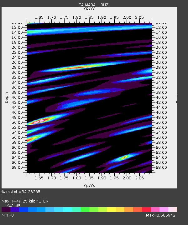
| Estimated Moho Depth: |
49.25 km |
| Estimated Crust Vp/Vs: |
1.65 |
| Assumed Crust Vp: |
6.498 km/s |
| Estimated Crust Vs: |
3.938 km/s |
| Estimated Crust Poisson's Ratio: |
0.21 |
|
| Radial Match: |
84.35285 % |
| Radial Bump: |
400 |
| Transverse Match: |
69.06913 % |
| Transverse Bump: |
400 |
| SOD ConfigId: |
512894 |
| Insert Time: |
2013-09-14 19:32:34.861 +0000 |
| GWidth: |
2.5 |
| Max Bumps: |
400 |
| Tol: |
0.001 |
|

Signal To Noise
| Channel | StoN | STA | LTA |
| TA:M43A: :BHZ:20130524T15:06:28.749978Z | 57.362896 | 6.674348E-6 | 1.1635305E-7 |
| TA:M43A: :BHN:20130524T15:06:28.749978Z | 13.695711 | 1.870508E-6 | 1.3657618E-7 |
| TA:M43A: :BHE:20130524T15:06:28.749978Z | 11.8568 | 1.8238779E-6 | 1.5382547E-7 |
| Arrivals |
| Ps | 5.1 SECOND |
| PpPs | 19 SECOND |
| PsPs/PpSs | 25 SECOND |


