You are here: Home > Network List > TA - USArray Transportable Network (new EarthScope stations) Stations List
> Station M48A Edgerton, OH, USA > Earthquake Result Viewer
M48A Edgerton, OH, USA - Earthquake Result Viewer
| Earthquake location: |
Sea Of Okhotsk |
| Earthquake latitude/longitude: |
52.2/151.4 |
| Earthquake time(UTC): |
2013/05/24 (144) 14:56:31 GMT |
| Earthquake Depth: |
624 km |
| Earthquake Magnitude: |
6.7 MW, 6.7 MB, 6.7 MW |
| Earthquake Catalog/Contributor: |
NEIC PDE/NEIC PDE-W |
|
| Network: |
TA USArray Transportable Network (new EarthScope stations) |
| Station: |
M48A Edgerton, OH, USA |
| Lat/Lon: |
41.48 N/84.72 W |
| Elevation: |
258 m |
|
| Distance: |
74.7 deg |
| Az: |
40.304 deg |
| Baz: |
328.031 deg |
| Ray Param: |
0.050054044 |
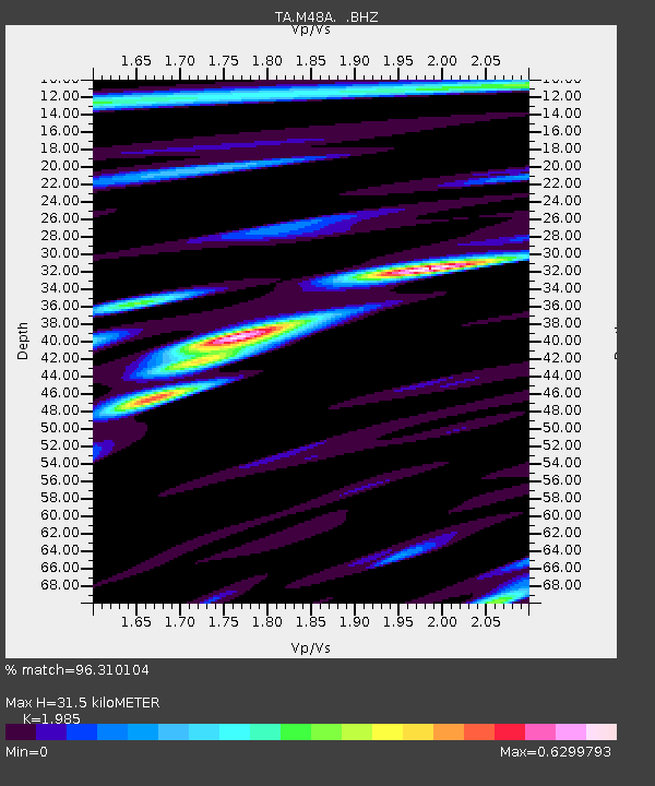
| Estimated Moho Depth: |
31.5 km |
| Estimated Crust Vp/Vs: |
1.99 |
| Assumed Crust Vp: |
6.498 km/s |
| Estimated Crust Vs: |
3.273 km/s |
| Estimated Crust Poisson's Ratio: |
0.33 |
|
| Radial Match: |
96.310104 % |
| Radial Bump: |
400 |
| Transverse Match: |
92.04101 % |
| Transverse Bump: |
400 |
| SOD ConfigId: |
512894 |
| Insert Time: |
2013-09-14 19:32:45.873 +0000 |
| GWidth: |
2.5 |
| Max Bumps: |
400 |
| Tol: |
0.001 |
|
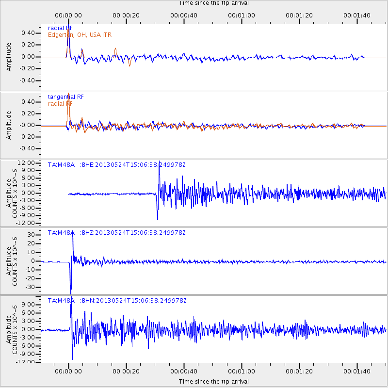
Signal To Noise
| Channel | StoN | STA | LTA |
| TA:M48A: :BHZ:20130524T15:06:38.249978Z | 68.63264 | 1.20935465E-5 | 1.7620694E-7 |
| TA:M48A: :BHN:20130524T15:06:38.249978Z | 39.955475 | 4.1572935E-6 | 1.0404816E-7 |
| TA:M48A: :BHE:20130524T15:06:38.249978Z | 28.167654 | 3.970879E-6 | 1.40973E-7 |
| Arrivals |
| Ps | 4.9 SECOND |
| PpPs | 14 SECOND |
| PsPs/PpSs | 19 SECOND |


