You are here: Home > Network List > TA - USArray Transportable Network (new EarthScope stations) Stations List
> Station M49A Liberty Center, OH, USA > Earthquake Result Viewer
M49A Liberty Center, OH, USA - Earthquake Result Viewer
| Earthquake location: |
Sea Of Okhotsk |
| Earthquake latitude/longitude: |
52.2/151.4 |
| Earthquake time(UTC): |
2013/05/24 (144) 14:56:31 GMT |
| Earthquake Depth: |
624 km |
| Earthquake Magnitude: |
6.7 MW, 6.7 MB, 6.7 MW |
| Earthquake Catalog/Contributor: |
NEIC PDE/NEIC PDE-W |
|
| Network: |
TA USArray Transportable Network (new EarthScope stations) |
| Station: |
M49A Liberty Center, OH, USA |
| Lat/Lon: |
41.47 N/83.98 W |
| Elevation: |
203 m |
|
| Distance: |
75.1 deg |
| Az: |
39.819 deg |
| Baz: |
328.394 deg |
| Ray Param: |
0.049858816 |
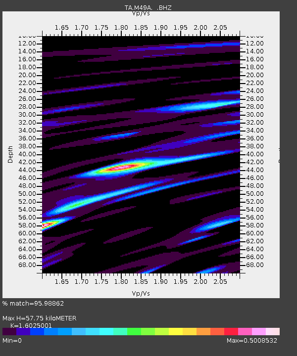
| Estimated Moho Depth: |
57.75 km |
| Estimated Crust Vp/Vs: |
1.60 |
| Assumed Crust Vp: |
6.498 km/s |
| Estimated Crust Vs: |
4.055 km/s |
| Estimated Crust Poisson's Ratio: |
0.18 |
|
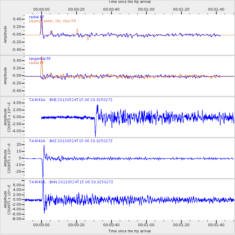
| Radial Match: |
95.98862 % |
| Radial Bump: |
400 |
| Transverse Match: |
88.17598 % |
| Transverse Bump: |
400 |
| SOD ConfigId: |
512894 |
| Insert Time: |
2013-09-14 19:32:52.227 +0000 |
| GWidth: |
2.5 |
| Max Bumps: |
400 |
| Tol: |
0.001 |
|
Signal To Noise
| Channel | StoN | STA | LTA |
| TA:M49A: :BHZ:20130524T15:06:39.925027Z | 45.277428 | 8.8142115E-6 | 1.946712E-7 |
| TA:M49A: :BHN:20130524T15:06:39.925027Z | 19.800692 | 2.7820909E-6 | 1.4050474E-7 |
| TA:M49A: :BHE:20130524T15:06:39.925027Z | 11.341943 | 1.8871981E-6 | 1.6639108E-7 |
| Arrivals |
| Ps | 5.5 SECOND |
| PpPs | 22 SECOND |
| PsPs/PpSs | 28 SECOND |


