You are here: Home > Network List > TA - USArray Transportable Network (new EarthScope stations) Stations List
> Station M53A WI Miller and Sons, Farmdale, OH, USA > Earthquake Result Viewer
M53A WI Miller and Sons, Farmdale, OH, USA - Earthquake Result Viewer
| Earthquake location: |
Sea Of Okhotsk |
| Earthquake latitude/longitude: |
52.2/151.4 |
| Earthquake time(UTC): |
2013/05/24 (144) 14:56:31 GMT |
| Earthquake Depth: |
624 km |
| Earthquake Magnitude: |
6.7 MW, 6.7 MB, 6.7 MW |
| Earthquake Catalog/Contributor: |
NEIC PDE/NEIC PDE-W |
|
| Network: |
TA USArray Transportable Network (new EarthScope stations) |
| Station: |
M53A WI Miller and Sons, Farmdale, OH, USA |
| Lat/Lon: |
41.44 N/80.68 W |
| Elevation: |
334 m |
|
| Distance: |
76.4 deg |
| Az: |
37.639 deg |
| Baz: |
330.032 deg |
| Ray Param: |
0.049019553 |
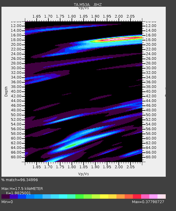
| Estimated Moho Depth: |
17.5 km |
| Estimated Crust Vp/Vs: |
1.98 |
| Assumed Crust Vp: |
6.483 km/s |
| Estimated Crust Vs: |
3.27 km/s |
| Estimated Crust Poisson's Ratio: |
0.33 |
|
| Radial Match: |
96.34996 % |
| Radial Bump: |
384 |
| Transverse Match: |
88.313095 % |
| Transverse Bump: |
400 |
| SOD ConfigId: |
512894 |
| Insert Time: |
2013-09-14 19:33:01.358 +0000 |
| GWidth: |
2.5 |
| Max Bumps: |
400 |
| Tol: |
0.001 |
|
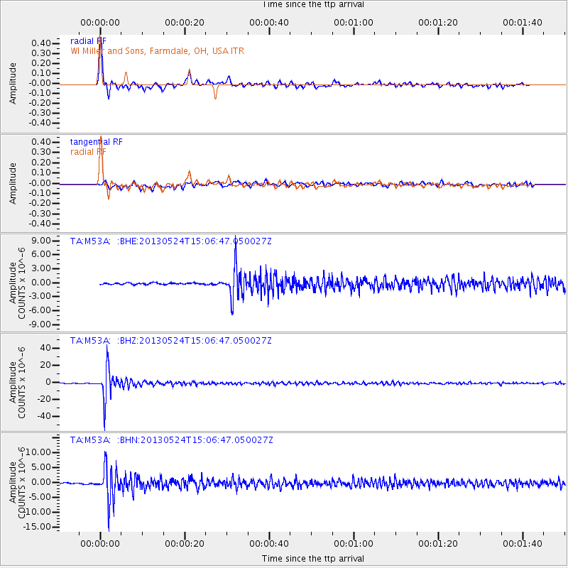
Signal To Noise
| Channel | StoN | STA | LTA |
| TA:M53A: :BHZ:20130524T15:06:47.050027Z | 64.16831 | 1.7284001E-5 | 2.6935413E-7 |
| TA:M53A: :BHN:20130524T15:06:47.050027Z | 33.705635 | 5.451746E-6 | 1.6174582E-7 |
| TA:M53A: :BHE:20130524T15:06:47.050027Z | 21.069017 | 3.3134877E-6 | 1.5726826E-7 |
| Arrivals |
| Ps | 2.7 SECOND |
| PpPs | 7.8 SECOND |
| PsPs/PpSs | 11 SECOND |


