You are here: Home > Network List > TA - USArray Transportable Network (new EarthScope stations) Stations List
> Station N44A Piper City, IL, USA > Earthquake Result Viewer
N44A Piper City, IL, USA - Earthquake Result Viewer

| Earthquake location: |
Sea Of Okhotsk |
| Earthquake latitude/longitude: |
52.2/151.4 |
| Earthquake time(UTC): |
2013/05/24 (144) 14:56:31 GMT |
| Earthquake Depth: |
624 km |
| Earthquake Magnitude: |
6.7 MW, 6.7 MB, 6.7 MW |
| Earthquake Catalog/Contributor: |
NEIC PDE/NEIC PDE-W |
|
| Network: |
TA USArray Transportable Network (new EarthScope stations) |
| Station: |
N44A Piper City, IL, USA |
| Lat/Lon: |
40.80 N/88.13 W |
| Elevation: |
202 m |
|
| Distance: |
73.9 deg |
| Az: |
42.945 deg |
| Baz: |
326.504 deg |
| Ray Param: |
0.050578088 |
| Estimated Moho Depth: |
44.5 km |
| Estimated Crust Vp/Vs: |
1.70 |
| Assumed Crust Vp: |
6.498 km/s |
| Estimated Crust Vs: |
3.822 km/s |
| Estimated Crust Poisson's Ratio: |
0.24 |
|
| Radial Match: |
90.62871 % |
| Radial Bump: |
398 |
| Transverse Match: |
83.98855 % |
| Transverse Bump: |
400 |
| SOD ConfigId: |
512894 |
| Insert Time: |
2013-09-14 19:33:31.785 +0000 |
| GWidth: |
2.5 |
| Max Bumps: |
400 |
| Tol: |
0.001 |
|
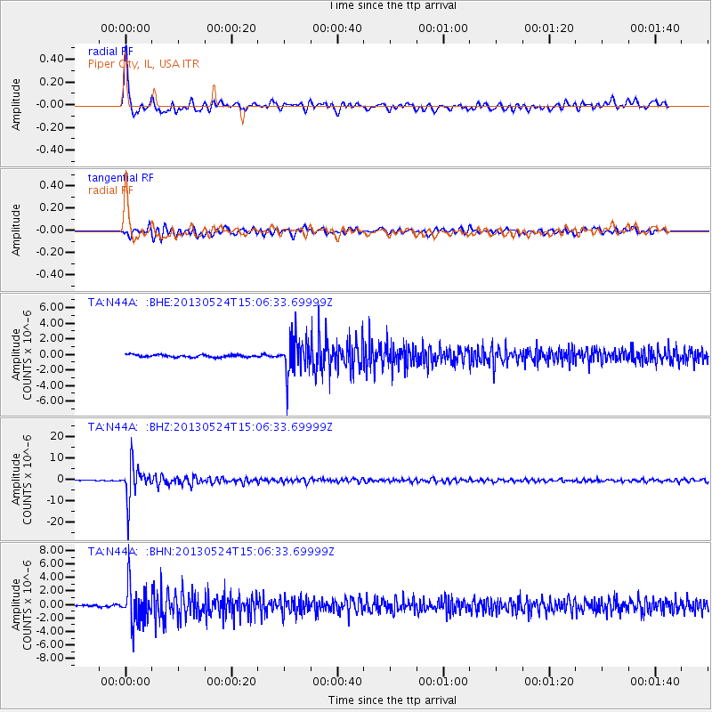
Signal To Noise
| Channel | StoN | STA | LTA |
| TA:N44A: :BHZ:20130524T15:06:33.69999Z | 47.755302 | 8.265359E-6 | 1.730773E-7 |
| TA:N44A: :BHN:20130524T15:06:33.69999Z | 19.186432 | 2.8039024E-6 | 1.4613984E-7 |
| TA:N44A: :BHE:20130524T15:06:33.69999Z | 14.820402 | 2.2561462E-6 | 1.5223246E-7 |
| Arrivals |
| Ps | 5.0 SECOND |
| PpPs | 18 SECOND |
| PsPs/PpSs | 23 SECOND |


