You are here: Home > Network List > TA - USArray Transportable Network (new EarthScope stations) Stations List
> Station N48A Decatur, IN, USA > Earthquake Result Viewer
N48A Decatur, IN, USA - Earthquake Result Viewer
| Earthquake location: |
Sea Of Okhotsk |
| Earthquake latitude/longitude: |
52.2/151.4 |
| Earthquake time(UTC): |
2013/05/24 (144) 14:56:31 GMT |
| Earthquake Depth: |
624 km |
| Earthquake Magnitude: |
6.7 MW, 6.7 MB, 6.7 MW |
| Earthquake Catalog/Contributor: |
NEIC PDE/NEIC PDE-W |
|
| Network: |
TA USArray Transportable Network (new EarthScope stations) |
| Station: |
N48A Decatur, IN, USA |
| Lat/Lon: |
40.86 N/85.03 W |
| Elevation: |
250 m |
|
| Distance: |
75.2 deg |
| Az: |
40.853 deg |
| Baz: |
327.97 deg |
| Ray Param: |
0.04979182 |
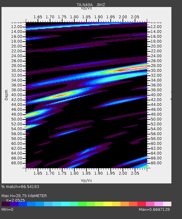
| Estimated Moho Depth: |
28.75 km |
| Estimated Crust Vp/Vs: |
2.05 |
| Assumed Crust Vp: |
6.498 km/s |
| Estimated Crust Vs: |
3.166 km/s |
| Estimated Crust Poisson's Ratio: |
0.34 |
|
| Radial Match: |
96.54183 % |
| Radial Bump: |
393 |
| Transverse Match: |
89.25992 % |
| Transverse Bump: |
400 |
| SOD ConfigId: |
512894 |
| Insert Time: |
2013-09-14 19:33:41.925 +0000 |
| GWidth: |
2.5 |
| Max Bumps: |
400 |
| Tol: |
0.001 |
|

Signal To Noise
| Channel | StoN | STA | LTA |
| TA:N48A: :BHZ:20130524T15:06:40.499978Z | 50.90603 | 1.0903134E-5 | 2.141816E-7 |
| TA:N48A: :BHN:20130524T15:06:40.499978Z | 25.40556 | 3.794582E-6 | 1.4936029E-7 |
| TA:N48A: :BHE:20130524T15:06:40.499978Z | 22.688688 | 3.0844142E-6 | 1.3594503E-7 |
| Arrivals |
| Ps | 4.8 SECOND |
| PpPs | 13 SECOND |
| PsPs/PpSs | 18 SECOND |


