You are here: Home > Network List > TA - USArray Transportable Network (new EarthScope stations) Stations List
> Station N50A Nevada, OH, USA > Earthquake Result Viewer
N50A Nevada, OH, USA - Earthquake Result Viewer
| Earthquake location: |
Sea Of Okhotsk |
| Earthquake latitude/longitude: |
52.2/151.4 |
| Earthquake time(UTC): |
2013/05/24 (144) 14:56:31 GMT |
| Earthquake Depth: |
624 km |
| Earthquake Magnitude: |
6.7 MW, 6.7 MB, 6.7 MW |
| Earthquake Catalog/Contributor: |
NEIC PDE/NEIC PDE-W |
|
| Network: |
TA USArray Transportable Network (new EarthScope stations) |
| Station: |
N50A Nevada, OH, USA |
| Lat/Lon: |
40.77 N/83.15 W |
| Elevation: |
277 m |
|
| Distance: |
76.0 deg |
| Az: |
39.646 deg |
| Baz: |
328.892 deg |
| Ray Param: |
0.049263123 |
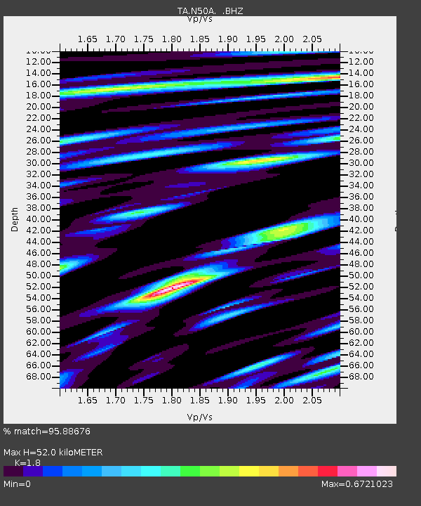
| Estimated Moho Depth: |
52.0 km |
| Estimated Crust Vp/Vs: |
1.80 |
| Assumed Crust Vp: |
6.498 km/s |
| Estimated Crust Vs: |
3.61 km/s |
| Estimated Crust Poisson's Ratio: |
0.28 |
|
| Radial Match: |
95.88676 % |
| Radial Bump: |
373 |
| Transverse Match: |
90.63402 % |
| Transverse Bump: |
400 |
| SOD ConfigId: |
512894 |
| Insert Time: |
2013-09-14 19:33:47.796 +0000 |
| GWidth: |
2.5 |
| Max Bumps: |
400 |
| Tol: |
0.001 |
|
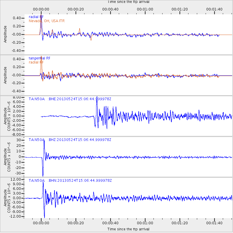
Signal To Noise
| Channel | StoN | STA | LTA |
| TA:N50A: :BHZ:20130524T15:06:44.999978Z | 61.10319 | 1.2515699E-5 | 2.0482891E-7 |
| TA:N50A: :BHN:20130524T15:06:44.999978Z | 29.547825 | 4.622017E-6 | 1.5642495E-7 |
| TA:N50A: :BHE:20130524T15:06:44.999978Z | 13.823606 | 2.8246718E-6 | 2.0433684E-7 |
| Arrivals |
| Ps | 6.6 SECOND |
| PpPs | 22 SECOND |
| PsPs/PpSs | 28 SECOND |


