You are here: Home > Network List > TA - USArray Transportable Network (new EarthScope stations) Stations List
> Station O47A Sheridan, IN, USA > Earthquake Result Viewer
O47A Sheridan, IN, USA - Earthquake Result Viewer
| Earthquake location: |
Sea Of Okhotsk |
| Earthquake latitude/longitude: |
52.2/151.4 |
| Earthquake time(UTC): |
2013/05/24 (144) 14:56:31 GMT |
| Earthquake Depth: |
624 km |
| Earthquake Magnitude: |
6.7 MW, 6.7 MB, 6.7 MW |
| Earthquake Catalog/Contributor: |
NEIC PDE/NEIC PDE-W |
|
| Network: |
TA USArray Transportable Network (new EarthScope stations) |
| Station: |
O47A Sheridan, IN, USA |
| Lat/Lon: |
40.24 N/86.17 W |
| Elevation: |
278 m |
|
| Distance: |
75.2 deg |
| Az: |
41.961 deg |
| Baz: |
327.51 deg |
| Ray Param: |
0.049753267 |
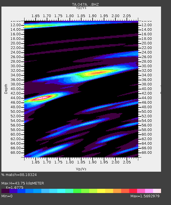
| Estimated Moho Depth: |
43.75 km |
| Estimated Crust Vp/Vs: |
1.68 |
| Assumed Crust Vp: |
6.498 km/s |
| Estimated Crust Vs: |
3.873 km/s |
| Estimated Crust Poisson's Ratio: |
0.22 |
|
| Radial Match: |
88.18324 % |
| Radial Bump: |
400 |
| Transverse Match: |
78.86088 % |
| Transverse Bump: |
400 |
| SOD ConfigId: |
512894 |
| Insert Time: |
2013-09-14 19:34:20.996 +0000 |
| GWidth: |
2.5 |
| Max Bumps: |
400 |
| Tol: |
0.001 |
|
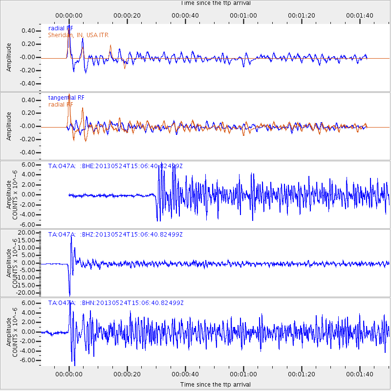
Signal To Noise
| Channel | StoN | STA | LTA |
| TA:O47A: :BHZ:20130524T15:06:40.82499Z | 36.03749 | 7.332616E-6 | 2.0347188E-7 |
| TA:O47A: :BHN:20130524T15:06:40.82499Z | 18.547129 | 2.9956764E-6 | 1.6151698E-7 |
| TA:O47A: :BHE:20130524T15:06:40.82499Z | 23.841612 | 2.880209E-6 | 1.2080596E-7 |
| Arrivals |
| Ps | 4.7 SECOND |
| PpPs | 17 SECOND |
| PsPs/PpSs | 22 SECOND |


