You are here: Home > Network List > TA - USArray Transportable Network (new EarthScope stations) Stations List
> Station O57A Amberson, PA, USA > Earthquake Result Viewer
O57A Amberson, PA, USA - Earthquake Result Viewer
| Earthquake location: |
Sea Of Okhotsk |
| Earthquake latitude/longitude: |
52.2/151.4 |
| Earthquake time(UTC): |
2013/05/24 (144) 14:56:31 GMT |
| Earthquake Depth: |
624 km |
| Earthquake Magnitude: |
6.7 MW, 6.7 MB, 6.7 MW |
| Earthquake Catalog/Contributor: |
NEIC PDE/NEIC PDE-W |
|
| Network: |
TA USArray Transportable Network (new EarthScope stations) |
| Station: |
O57A Amberson, PA, USA |
| Lat/Lon: |
40.21 N/77.64 W |
| Elevation: |
377 m |
|
| Distance: |
78.5 deg |
| Az: |
36.187 deg |
| Baz: |
331.696 deg |
| Ray Param: |
0.047587845 |
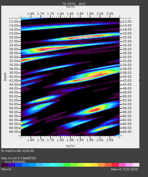
| Estimated Moho Depth: |
19.5 km |
| Estimated Crust Vp/Vs: |
1.93 |
| Assumed Crust Vp: |
6.121 km/s |
| Estimated Crust Vs: |
3.171 km/s |
| Estimated Crust Poisson's Ratio: |
0.32 |
|
| Radial Match: |
96.316185 % |
| Radial Bump: |
400 |
| Transverse Match: |
88.45391 % |
| Transverse Bump: |
400 |
| SOD ConfigId: |
512894 |
| Insert Time: |
2013-09-14 19:34:48.124 +0000 |
| GWidth: |
2.5 |
| Max Bumps: |
400 |
| Tol: |
0.001 |
|

Signal To Noise
| Channel | StoN | STA | LTA |
| TA:O57A: :BHZ:20130524T15:06:58.800027Z | 118.45468 | 1.2068385E-5 | 1.01881874E-7 |
| TA:O57A: :BHN:20130524T15:06:58.800027Z | 37.92011 | 3.9410525E-6 | 1.0393041E-7 |
| TA:O57A: :BHE:20130524T15:06:58.800027Z | 10.594602 | 1.6921281E-6 | 1.5971607E-7 |
| Arrivals |
| Ps | 3.0 SECOND |
| PpPs | 9.1 SECOND |
| PsPs/PpSs | 12 SECOND |


