You are here: Home > Network List > TA - USArray Transportable Network (new EarthScope stations) Stations List
> Station Q47A Bedord North Lawrence Stars, Bedford, IN, USA > Earthquake Result Viewer
Q47A Bedord North Lawrence Stars, Bedford, IN, USA - Earthquake Result Viewer
| Earthquake location: |
Sea Of Okhotsk |
| Earthquake latitude/longitude: |
52.2/151.4 |
| Earthquake time(UTC): |
2013/05/24 (144) 14:56:31 GMT |
| Earthquake Depth: |
624 km |
| Earthquake Magnitude: |
6.7 MW, 6.7 MB, 6.7 MW |
| Earthquake Catalog/Contributor: |
NEIC PDE/NEIC PDE-W |
|
| Network: |
TA USArray Transportable Network (new EarthScope stations) |
| Station: |
Q47A Bedord North Lawrence Stars, Bedford, IN, USA |
| Lat/Lon: |
38.94 N/86.43 W |
| Elevation: |
230 m |
|
| Distance: |
76.2 deg |
| Az: |
42.849 deg |
| Baz: |
327.57 deg |
| Ray Param: |
0.049114276 |
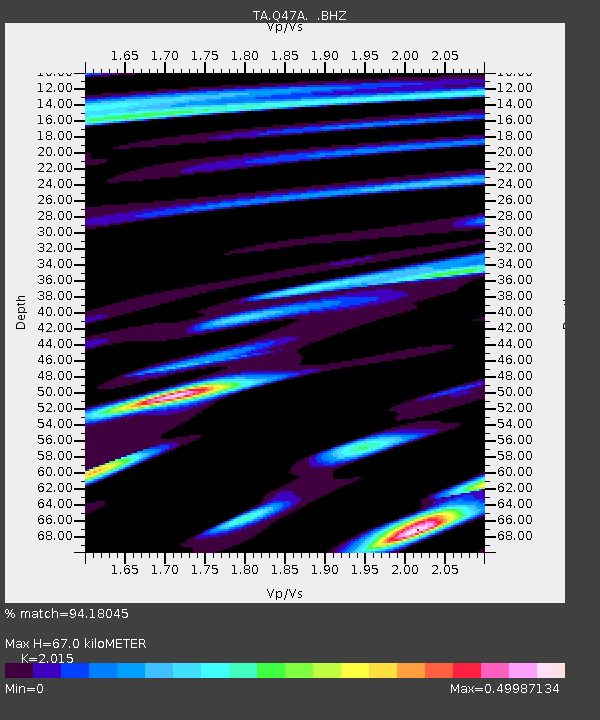
| Estimated Moho Depth: |
67.0 km |
| Estimated Crust Vp/Vs: |
2.02 |
| Assumed Crust Vp: |
6.444 km/s |
| Estimated Crust Vs: |
3.198 km/s |
| Estimated Crust Poisson's Ratio: |
0.34 |
|
| Radial Match: |
94.18045 % |
| Radial Bump: |
400 |
| Transverse Match: |
88.34943 % |
| Transverse Bump: |
400 |
| SOD ConfigId: |
512894 |
| Insert Time: |
2013-09-14 19:35:52.607 +0000 |
| GWidth: |
2.5 |
| Max Bumps: |
400 |
| Tol: |
0.001 |
|

Signal To Noise
| Channel | StoN | STA | LTA |
| TA:Q47A: :BHZ:20130524T15:06:46.249978Z | 71.14658 | 1.2829735E-5 | 1.803282E-7 |
| TA:Q47A: :BHN:20130524T15:06:46.249978Z | 24.512041 | 3.0197782E-6 | 1.231957E-7 |
| TA:Q47A: :BHE:20130524T15:06:46.249978Z | 13.810152 | 1.9994966E-6 | 1.4478454E-7 |
| Arrivals |
| Ps | 11 SECOND |
| PpPs | 31 SECOND |
| PsPs/PpSs | 41 SECOND |


