You are here: Home > Network List > TA - USArray Transportable Network (new EarthScope stations) Stations List
> Station Q51A Peebles, OH, USA > Earthquake Result Viewer
Q51A Peebles, OH, USA - Earthquake Result Viewer
| Earthquake location: |
Sea Of Okhotsk |
| Earthquake latitude/longitude: |
52.2/151.4 |
| Earthquake time(UTC): |
2013/05/24 (144) 14:56:31 GMT |
| Earthquake Depth: |
624 km |
| Earthquake Magnitude: |
6.7 MW, 6.7 MB, 6.7 MW |
| Earthquake Catalog/Contributor: |
NEIC PDE/NEIC PDE-W |
|
| Network: |
TA USArray Transportable Network (new EarthScope stations) |
| Station: |
Q51A Peebles, OH, USA |
| Lat/Lon: |
39.03 N/83.35 W |
| Elevation: |
362 m |
|
| Distance: |
77.4 deg |
| Az: |
40.703 deg |
| Baz: |
329.01 deg |
| Ray Param: |
0.04834366 |
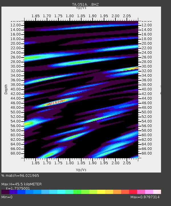
| Estimated Moho Depth: |
45.5 km |
| Estimated Crust Vp/Vs: |
1.74 |
| Assumed Crust Vp: |
6.232 km/s |
| Estimated Crust Vs: |
3.587 km/s |
| Estimated Crust Poisson's Ratio: |
0.25 |
|
| Radial Match: |
96.021965 % |
| Radial Bump: |
400 |
| Transverse Match: |
92.40847 % |
| Transverse Bump: |
400 |
| SOD ConfigId: |
512894 |
| Insert Time: |
2013-09-14 19:36:03.734 +0000 |
| GWidth: |
2.5 |
| Max Bumps: |
400 |
| Tol: |
0.001 |
|
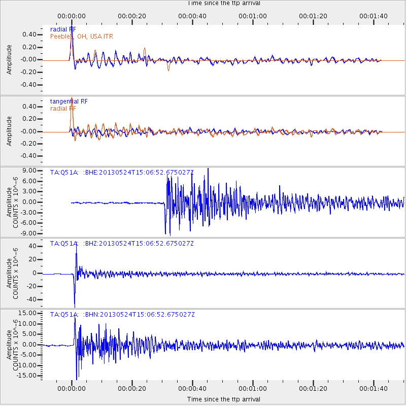
Signal To Noise
| Channel | StoN | STA | LTA |
| TA:Q51A: :BHZ:20130524T15:06:52.675027Z | 99.53241 | 1.3889983E-5 | 1.3955237E-7 |
| TA:Q51A: :BHN:20130524T15:06:52.675027Z | 43.0511 | 5.7434218E-6 | 1.334094E-7 |
| TA:Q51A: :BHE:20130524T15:06:52.675027Z | 37.50592 | 3.6729723E-6 | 9.793047E-8 |
| Arrivals |
| Ps | 5.5 SECOND |
| PpPs | 19 SECOND |
| PsPs/PpSs | 25 SECOND |


