You are here: Home > Network List > TA - USArray Transportable Network (new EarthScope stations) Stations List
> Station Q59A Harwood, MD, USA > Earthquake Result Viewer
Q59A Harwood, MD, USA - Earthquake Result Viewer
| Earthquake location: |
Sea Of Okhotsk |
| Earthquake latitude/longitude: |
52.2/151.4 |
| Earthquake time(UTC): |
2013/05/24 (144) 14:56:31 GMT |
| Earthquake Depth: |
624 km |
| Earthquake Magnitude: |
6.7 MW, 6.7 MB, 6.7 MW |
| Earthquake Catalog/Contributor: |
NEIC PDE/NEIC PDE-W |
|
| Network: |
TA USArray Transportable Network (new EarthScope stations) |
| Station: |
Q59A Harwood, MD, USA |
| Lat/Lon: |
38.86 N/76.65 W |
| Elevation: |
34 m |
|
| Distance: |
80.1 deg |
| Az: |
36.148 deg |
| Baz: |
332.311 deg |
| Ray Param: |
0.046565436 |
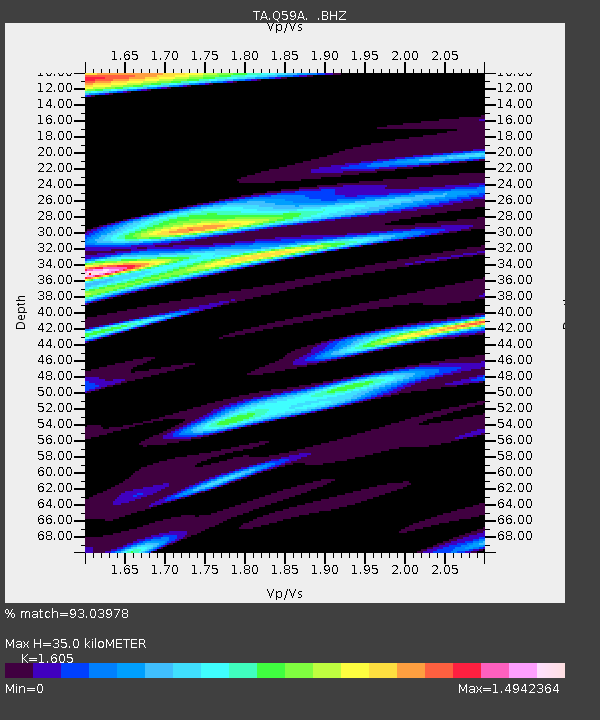
| Estimated Moho Depth: |
35.0 km |
| Estimated Crust Vp/Vs: |
1.61 |
| Assumed Crust Vp: |
6.419 km/s |
| Estimated Crust Vs: |
4.0 km/s |
| Estimated Crust Poisson's Ratio: |
0.18 |
|
| Radial Match: |
93.03978 % |
| Radial Bump: |
400 |
| Transverse Match: |
88.12609 % |
| Transverse Bump: |
400 |
| SOD ConfigId: |
512894 |
| Insert Time: |
2013-09-14 19:36:22.823 +0000 |
| GWidth: |
2.5 |
| Max Bumps: |
400 |
| Tol: |
0.001 |
|

Signal To Noise
| Channel | StoN | STA | LTA |
| TA:Q59A: :BHZ:20130524T15:07:06.850015Z | 48.961384 | 2.7099157E-5 | 5.534802E-7 |
| TA:Q59A: :BHN:20130524T15:07:06.850015Z | 12.714304 | 9.932825E-6 | 7.812323E-7 |
| TA:Q59A: :BHE:20130524T15:07:06.850015Z | 7.4927454 | 6.039569E-6 | 8.0605554E-7 |
| Arrivals |
| Ps | 3.4 SECOND |
| PpPs | 14 SECOND |
| PsPs/PpSs | 17 SECOND |


