You are here: Home > Network List > TA - USArray Transportable Network (new EarthScope stations) Stations List
> Station R41A Rosebud, MO, USA > Earthquake Result Viewer
R41A Rosebud, MO, USA - Earthquake Result Viewer
| Earthquake location: |
Sea Of Okhotsk |
| Earthquake latitude/longitude: |
52.2/151.4 |
| Earthquake time(UTC): |
2013/05/24 (144) 14:56:31 GMT |
| Earthquake Depth: |
624 km |
| Earthquake Magnitude: |
6.7 MW, 6.7 MB, 6.7 MW |
| Earthquake Catalog/Contributor: |
NEIC PDE/NEIC PDE-W |
|
| Network: |
TA USArray Transportable Network (new EarthScope stations) |
| Station: |
R41A Rosebud, MO, USA |
| Lat/Lon: |
38.30 N/91.38 W |
| Elevation: |
257 m |
|
| Distance: |
74.6 deg |
| Az: |
46.556 deg |
| Baz: |
325.424 deg |
| Ray Param: |
0.05015373 |
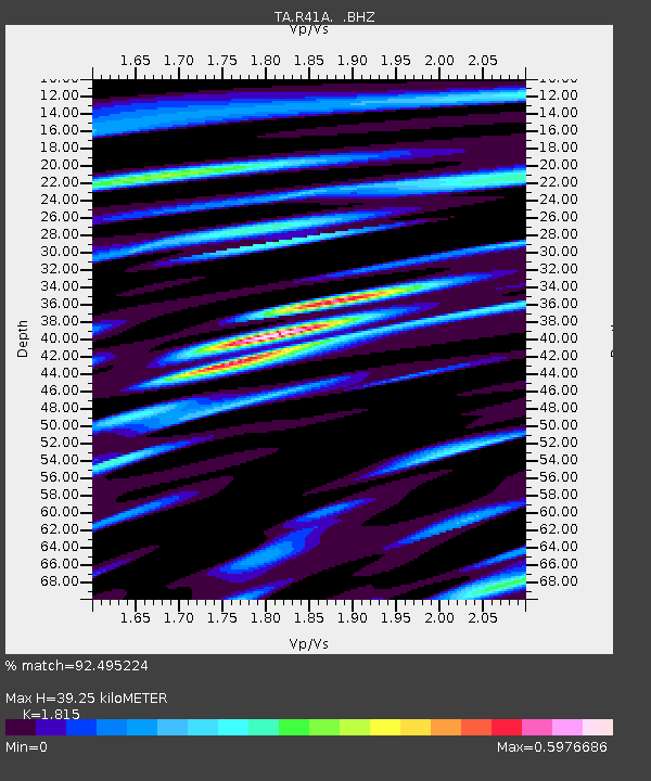
| Estimated Moho Depth: |
39.25 km |
| Estimated Crust Vp/Vs: |
1.82 |
| Assumed Crust Vp: |
6.498 km/s |
| Estimated Crust Vs: |
3.58 km/s |
| Estimated Crust Poisson's Ratio: |
0.28 |
|
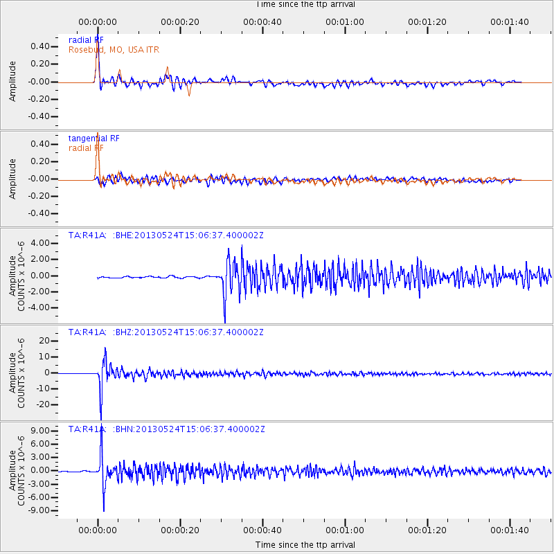
| Radial Match: |
92.495224 % |
| Radial Bump: |
400 |
| Transverse Match: |
80.945274 % |
| Transverse Bump: |
400 |
| SOD ConfigId: |
512894 |
| Insert Time: |
2013-09-14 19:36:28.490 +0000 |
| GWidth: |
2.5 |
| Max Bumps: |
400 |
| Tol: |
0.001 |
|
Signal To Noise
| Channel | StoN | STA | LTA |
| TA:R41A: :BHZ:20130524T15:06:37.400002Z | 114.21192 | 8.478288E-6 | 7.423295E-8 |
| TA:R41A: :BHN:20130524T15:06:37.400002Z | 36.4723 | 3.3096378E-6 | 9.0743875E-8 |
| TA:R41A: :BHE:20130524T15:06:37.400002Z | 22.278204 | 2.0438213E-6 | 9.174085E-8 |
| Arrivals |
| Ps | 5.1 SECOND |
| PpPs | 16 SECOND |
| PsPs/PpSs | 22 SECOND |


