You are here: Home > Network List > TA - USArray Transportable Network (new EarthScope stations) Stations List
> Station R46A Gibon Southern Titans, Haubstabt, IN, USA > Earthquake Result Viewer
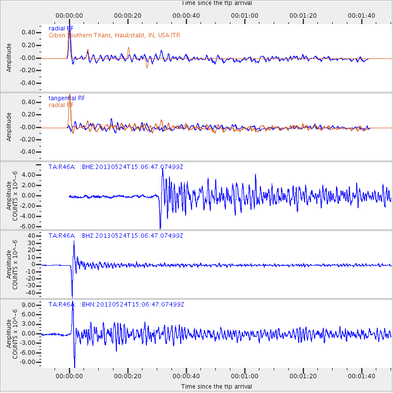
R46A Gibon Southern Titans, Haubstabt, IN, USA - Earthquake Result Viewer

| Earthquake location: |
Sea Of Okhotsk |
| Earthquake latitude/longitude: |
52.2/151.4 |
| Earthquake time(UTC): |
2013/05/24 (144) 14:56:31 GMT |
| Earthquake Depth: |
624 km |
| Earthquake Magnitude: |
6.7 MW, 6.7 MB, 6.7 MW |
| Earthquake Catalog/Contributor: |
NEIC PDE/NEIC PDE-W |
|
| Network: |
TA USArray Transportable Network (new EarthScope stations) |
| Station: |
R46A Gibon Southern Titans, Haubstabt, IN, USA |
| Lat/Lon: |
38.21 N/87.51 W |
| Elevation: |
164 m |
|
| Distance: |
76.4 deg |
| Az: |
43.988 deg |
| Baz: |
327.166 deg |
| Ray Param: |
0.049016796 |
| Estimated Moho Depth: |
54.5 km |
| Estimated Crust Vp/Vs: |
1.72 |
| Assumed Crust Vp: |
6.444 km/s |
| Estimated Crust Vs: |
3.752 km/s |
| Estimated Crust Poisson's Ratio: |
0.24 |
|
| Radial Match: |
94.506195 % |
| Radial Bump: |
400 |
| Transverse Match: |
90.466255 % |
| Transverse Bump: |
400 |
| SOD ConfigId: |
512894 |
| Insert Time: |
2013-09-14 19:36:34.566 +0000 |
| GWidth: |
2.5 |
| Max Bumps: |
400 |
| Tol: |
0.001 |
|
Signal To Noise
| Channel | StoN | STA | LTA |
| TA:R46A: :BHZ:20130524T15:06:47.07499Z | 77.17666 | 1.2649679E-5 | 1.639055E-7 |
| TA:R46A: :BHN:20130524T15:06:47.07499Z | 28.719906 | 3.7188036E-6 | 1.2948523E-7 |
| TA:R46A: :BHE:20130524T15:06:47.07499Z | 21.01379 | 2.5525458E-6 | 1.2147004E-7 |
| Arrivals |
| Ps | 6.3 SECOND |
| PpPs | 22 SECOND |
| PsPs/PpSs | 29 SECOND |


