You are here: Home > Network List > TA - USArray Transportable Network (new EarthScope stations) Stations List
> Station S47A Hartford, KY, USA > Earthquake Result Viewer
S47A Hartford, KY, USA - Earthquake Result Viewer
| Earthquake location: |
Sea Of Okhotsk |
| Earthquake latitude/longitude: |
52.2/151.4 |
| Earthquake time(UTC): |
2013/05/24 (144) 14:56:31 GMT |
| Earthquake Depth: |
624 km |
| Earthquake Magnitude: |
6.7 MW, 6.7 MB, 6.7 MW |
| Earthquake Catalog/Contributor: |
NEIC PDE/NEIC PDE-W |
|
| Network: |
TA USArray Transportable Network (new EarthScope stations) |
| Station: |
S47A Hartford, KY, USA |
| Lat/Lon: |
37.59 N/86.88 W |
| Elevation: |
181 m |
|
| Distance: |
77.1 deg |
| Az: |
43.896 deg |
| Baz: |
327.532 deg |
| Ray Param: |
0.04850357 |
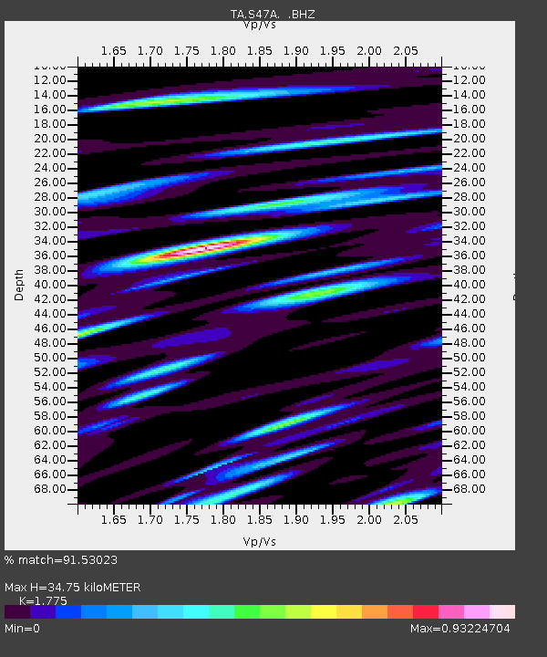
| Estimated Moho Depth: |
34.75 km |
| Estimated Crust Vp/Vs: |
1.77 |
| Assumed Crust Vp: |
6.444 km/s |
| Estimated Crust Vs: |
3.63 km/s |
| Estimated Crust Poisson's Ratio: |
0.27 |
|
| Radial Match: |
91.53023 % |
| Radial Bump: |
400 |
| Transverse Match: |
81.19915 % |
| Transverse Bump: |
400 |
| SOD ConfigId: |
512894 |
| Insert Time: |
2013-09-14 19:37:23.081 +0000 |
| GWidth: |
2.5 |
| Max Bumps: |
400 |
| Tol: |
0.001 |
|

Signal To Noise
| Channel | StoN | STA | LTA |
| TA:S47A: :BHZ:20130524T15:06:51.348977Z | 64.45161 | 6.7027195E-6 | 1.0399615E-7 |
| TA:S47A: :BHN:20130524T15:06:51.348977Z | 31.550882 | 3.477009E-6 | 1.1020322E-7 |
| TA:S47A: :BHE:20130524T15:06:51.348977Z | 23.796808 | 2.0664374E-6 | 8.683675E-8 |
| Arrivals |
| Ps | 4.3 SECOND |
| PpPs | 15 SECOND |
| PsPs/PpSs | 19 SECOND |


