You are here: Home > Network List > TA - USArray Transportable Network (new EarthScope stations) Stations List
> Station S59A Mechanicsville, VA, USA > Earthquake Result Viewer
S59A Mechanicsville, VA, USA - Earthquake Result Viewer
| Earthquake location: |
Sea Of Okhotsk |
| Earthquake latitude/longitude: |
52.2/151.4 |
| Earthquake time(UTC): |
2013/05/24 (144) 14:56:31 GMT |
| Earthquake Depth: |
624 km |
| Earthquake Magnitude: |
6.7 MW, 6.7 MB, 6.7 MW |
| Earthquake Catalog/Contributor: |
NEIC PDE/NEIC PDE-W |
|
| Network: |
TA USArray Transportable Network (new EarthScope stations) |
| Station: |
S59A Mechanicsville, VA, USA |
| Lat/Lon: |
37.46 N/77.18 W |
| Elevation: |
40 m |
|
| Distance: |
81.1 deg |
| Az: |
37.18 deg |
| Baz: |
332.158 deg |
| Ray Param: |
0.04585917 |
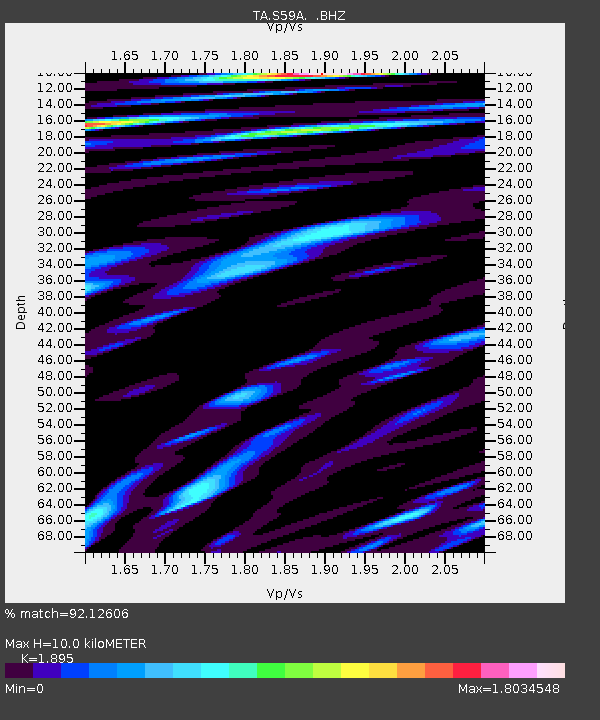
| Estimated Moho Depth: |
10.0 km |
| Estimated Crust Vp/Vs: |
1.89 |
| Assumed Crust Vp: |
6.565 km/s |
| Estimated Crust Vs: |
3.464 km/s |
| Estimated Crust Poisson's Ratio: |
0.31 |
|
| Radial Match: |
92.12606 % |
| Radial Bump: |
400 |
| Transverse Match: |
86.13953 % |
| Transverse Bump: |
400 |
| SOD ConfigId: |
512894 |
| Insert Time: |
2013-09-14 19:37:55.034 +0000 |
| GWidth: |
2.5 |
| Max Bumps: |
400 |
| Tol: |
0.001 |
|
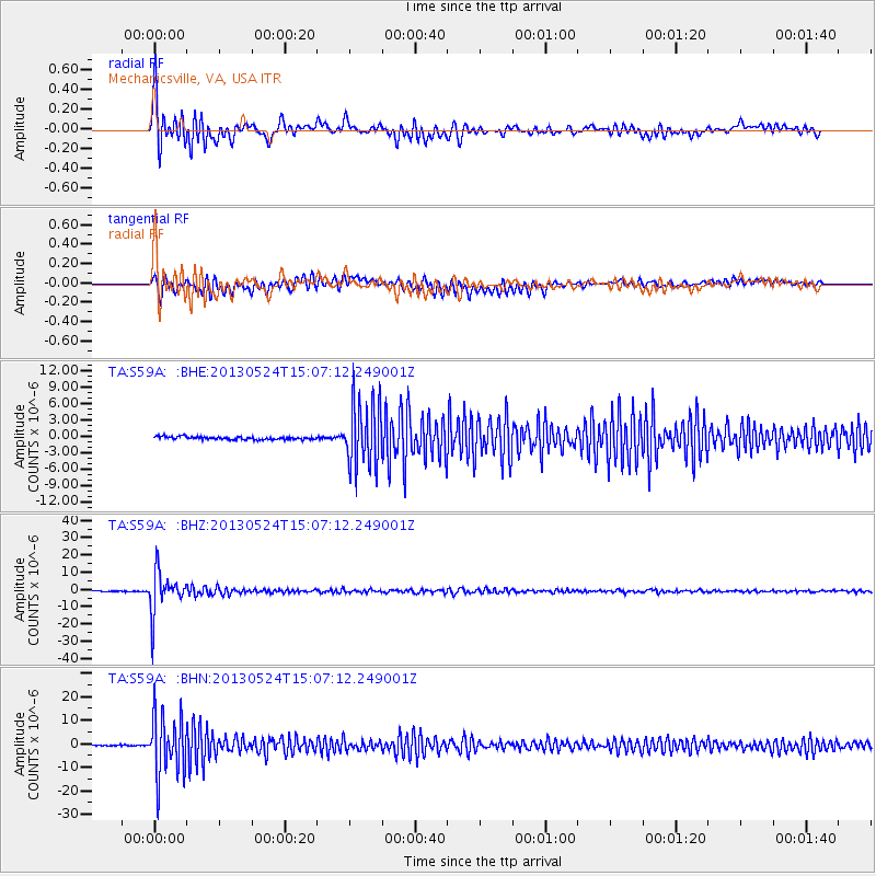
Signal To Noise
| Channel | StoN | STA | LTA |
| TA:S59A: :BHZ:20130524T15:07:12.249001Z | 74.46876 | 1.2243788E-5 | 1.6441508E-7 |
| TA:S59A: :BHN:20130524T15:07:12.249001Z | 60.364613 | 1.2803329E-5 | 2.120999E-7 |
| TA:S59A: :BHE:20130524T15:07:12.249001Z | 22.685263 | 6.06222E-6 | 2.6723166E-7 |
| Arrivals |
| Ps | 1.4 SECOND |
| PpPs | 4.3 SECOND |
| PsPs/PpSs | 5.7 SECOND |


