You are here: Home > Network List > TA - USArray Transportable Network (new EarthScope stations) Stations List
> Station T54A Tazewell, VA, USA > Earthquake Result Viewer
T54A Tazewell, VA, USA - Earthquake Result Viewer
| Earthquake location: |
Sea Of Okhotsk |
| Earthquake latitude/longitude: |
52.2/151.4 |
| Earthquake time(UTC): |
2013/05/24 (144) 14:56:31 GMT |
| Earthquake Depth: |
624 km |
| Earthquake Magnitude: |
6.7 MW, 6.7 MB, 6.7 MW |
| Earthquake Catalog/Contributor: |
NEIC PDE/NEIC PDE-W |
|
| Network: |
TA USArray Transportable Network (new EarthScope stations) |
| Station: |
T54A Tazewell, VA, USA |
| Lat/Lon: |
37.06 N/81.58 W |
| Elevation: |
852 m |
|
| Distance: |
79.8 deg |
| Az: |
40.49 deg |
| Baz: |
330.053 deg |
| Ray Param: |
0.04676265 |
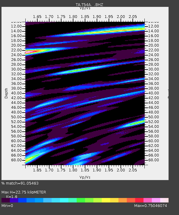
| Estimated Moho Depth: |
22.75 km |
| Estimated Crust Vp/Vs: |
1.60 |
| Assumed Crust Vp: |
6.159 km/s |
| Estimated Crust Vs: |
3.849 km/s |
| Estimated Crust Poisson's Ratio: |
0.18 |
|
| Radial Match: |
91.05463 % |
| Radial Bump: |
400 |
| Transverse Match: |
79.32579 % |
| Transverse Bump: |
400 |
| SOD ConfigId: |
512894 |
| Insert Time: |
2013-09-14 19:38:32.866 +0000 |
| GWidth: |
2.5 |
| Max Bumps: |
400 |
| Tol: |
0.001 |
|
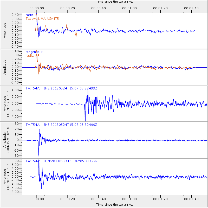
Signal To Noise
| Channel | StoN | STA | LTA |
| TA:T54A: :BHZ:20130524T15:07:05.32499Z | 88.26814 | 9.82807E-6 | 1.1134333E-7 |
| TA:T54A: :BHN:20130524T15:07:05.32499Z | 8.2754345 | 2.998323E-6 | 3.623161E-7 |
| TA:T54A: :BHE:20130524T15:07:05.32499Z | 20.744719 | 1.8087753E-6 | 8.7192085E-8 |
| Arrivals |
| Ps | 2.3 SECOND |
| PpPs | 9.4 SECOND |
| PsPs/PpSs | 12 SECOND |


