You are here: Home > Network List > TA - USArray Transportable Network (new EarthScope stations) Stations List
> Station T55A Pulaski, VA, USA > Earthquake Result Viewer
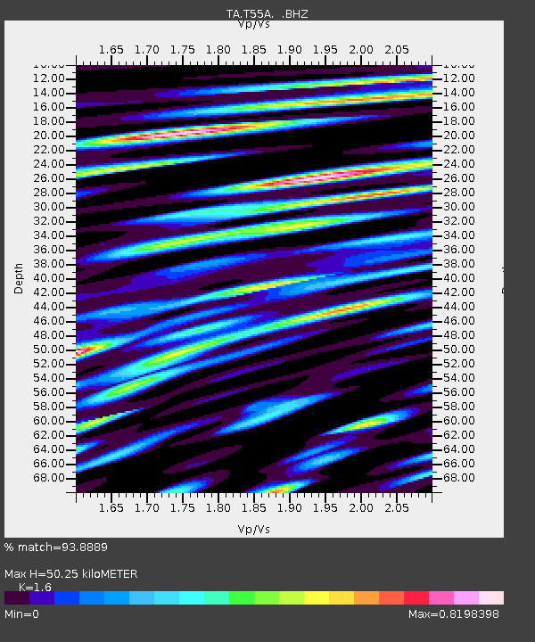
T55A Pulaski, VA, USA - Earthquake Result Viewer
| Earthquake location: |
Sea Of Okhotsk |
| Earthquake latitude/longitude: |
52.2/151.4 |
| Earthquake time(UTC): |
2013/05/24 (144) 14:56:31 GMT |
| Earthquake Depth: |
624 km |
| Earthquake Magnitude: |
6.7 MW, 6.7 MB, 6.7 MW |
| Earthquake Catalog/Contributor: |
NEIC PDE/NEIC PDE-W |
|
| Network: |
TA USArray Transportable Network (new EarthScope stations) |
| Station: |
T55A Pulaski, VA, USA |
| Lat/Lon: |
37.12 N/80.78 W |
| Elevation: |
644 m |
|
| Distance: |
80.1 deg |
| Az: |
39.903 deg |
| Baz: |
330.426 deg |
| Ray Param: |
0.046587203 |
| Estimated Moho Depth: |
50.25 km |
| Estimated Crust Vp/Vs: |
1.60 |
| Assumed Crust Vp: |
6.159 km/s |
| Estimated Crust Vs: |
3.849 km/s |
| Estimated Crust Poisson's Ratio: |
0.18 |
|
| Radial Match: |
93.8889 % |
| Radial Bump: |
400 |
| Transverse Match: |
90.200745 % |
| Transverse Bump: |
400 |
| SOD ConfigId: |
512894 |
| Insert Time: |
2013-09-14 19:38:35.474 +0000 |
| GWidth: |
2.5 |
| Max Bumps: |
400 |
| Tol: |
0.001 |
|

Signal To Noise
| Channel | StoN | STA | LTA |
| TA:T55A: :BHZ:20130524T15:07:06.69999Z | 80.91399 | 1.1812501E-5 | 1.4598838E-7 |
| TA:T55A: :BHN:20130524T15:07:06.69999Z | 30.707088 | 4.639313E-6 | 1.510828E-7 |
| TA:T55A: :BHE:20130524T15:07:06.69999Z | 21.205399 | 2.8608952E-6 | 1.3491353E-7 |
| Arrivals |
| Ps | 5.0 SECOND |
| PpPs | 21 SECOND |
| PsPs/PpSs | 26 SECOND |


