You are here: Home > Network List > TA - USArray Transportable Network (new EarthScope stations) Stations List
> Station T59A Double 'B' Farms, VA, USA > Earthquake Result Viewer
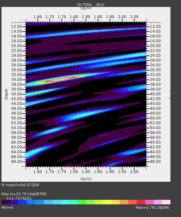
T59A Double 'B' Farms, VA, USA - Earthquake Result Viewer
| Earthquake location: |
Sea Of Okhotsk |
| Earthquake latitude/longitude: |
52.2/151.4 |
| Earthquake time(UTC): |
2013/05/24 (144) 14:56:31 GMT |
| Earthquake Depth: |
624 km |
| Earthquake Magnitude: |
6.7 MW, 6.7 MB, 6.7 MW |
| Earthquake Catalog/Contributor: |
NEIC PDE/NEIC PDE-W |
|
| Network: |
TA USArray Transportable Network (new EarthScope stations) |
| Station: |
T59A Double 'B' Farms, VA, USA |
| Lat/Lon: |
36.97 N/77.55 W |
| Elevation: |
63 m |
|
| Distance: |
81.4 deg |
| Az: |
37.679 deg |
| Baz: |
332.006 deg |
| Ray Param: |
0.0456695 |
| Estimated Moho Depth: |
33.75 km |
| Estimated Crust Vp/Vs: |
1.74 |
| Assumed Crust Vp: |
6.565 km/s |
| Estimated Crust Vs: |
3.778 km/s |
| Estimated Crust Poisson's Ratio: |
0.25 |
|
| Radial Match: |
94.87089 % |
| Radial Bump: |
272 |
| Transverse Match: |
89.19164 % |
| Transverse Bump: |
400 |
| SOD ConfigId: |
512894 |
| Insert Time: |
2013-09-14 19:38:45.033 +0000 |
| GWidth: |
2.5 |
| Max Bumps: |
400 |
| Tol: |
0.001 |
|

Signal To Noise
| Channel | StoN | STA | LTA |
| TA:T59A: :BHZ:20130524T15:07:13.69999Z | 77.43162 | 9.205477E-6 | 1.1888525E-7 |
| TA:T59A: :BHN:20130524T15:07:13.69999Z | 35.891438 | 2.8862173E-6 | 8.0415205E-8 |
| TA:T59A: :BHE:20130524T15:07:13.69999Z | 13.987599 | 1.8288054E-6 | 1.3074477E-7 |
| Arrivals |
| Ps | 3.9 SECOND |
| PpPs | 14 SECOND |
| PsPs/PpSs | 18 SECOND |


