You are here: Home > Network List > TA - USArray Transportable Network (new EarthScope stations) Stations List
> Station U41A Viola, AR, USA > Earthquake Result Viewer
U41A Viola, AR, USA - Earthquake Result Viewer
| Earthquake location: |
Sea Of Okhotsk |
| Earthquake latitude/longitude: |
52.2/151.4 |
| Earthquake time(UTC): |
2013/05/24 (144) 14:56:31 GMT |
| Earthquake Depth: |
624 km |
| Earthquake Magnitude: |
6.7 MW, 6.7 MB, 6.7 MW |
| Earthquake Catalog/Contributor: |
NEIC PDE/NEIC PDE-W |
|
| Network: |
TA USArray Transportable Network (new EarthScope stations) |
| Station: |
U41A Viola, AR, USA |
| Lat/Lon: |
36.34 N/91.92 W |
| Elevation: |
300 m |
|
| Distance: |
76.0 deg |
| Az: |
48.067 deg |
| Baz: |
325.482 deg |
| Ray Param: |
0.049275845 |
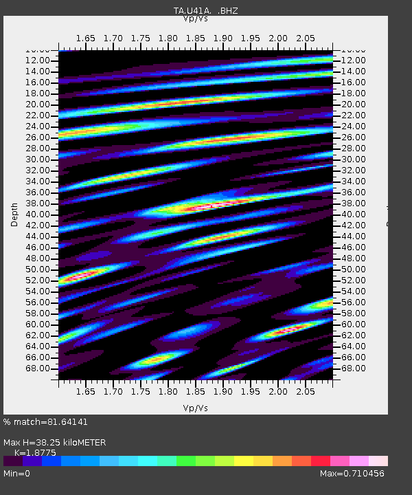
| Estimated Moho Depth: |
38.25 km |
| Estimated Crust Vp/Vs: |
1.88 |
| Assumed Crust Vp: |
6.53 km/s |
| Estimated Crust Vs: |
3.478 km/s |
| Estimated Crust Poisson's Ratio: |
0.30 |
|
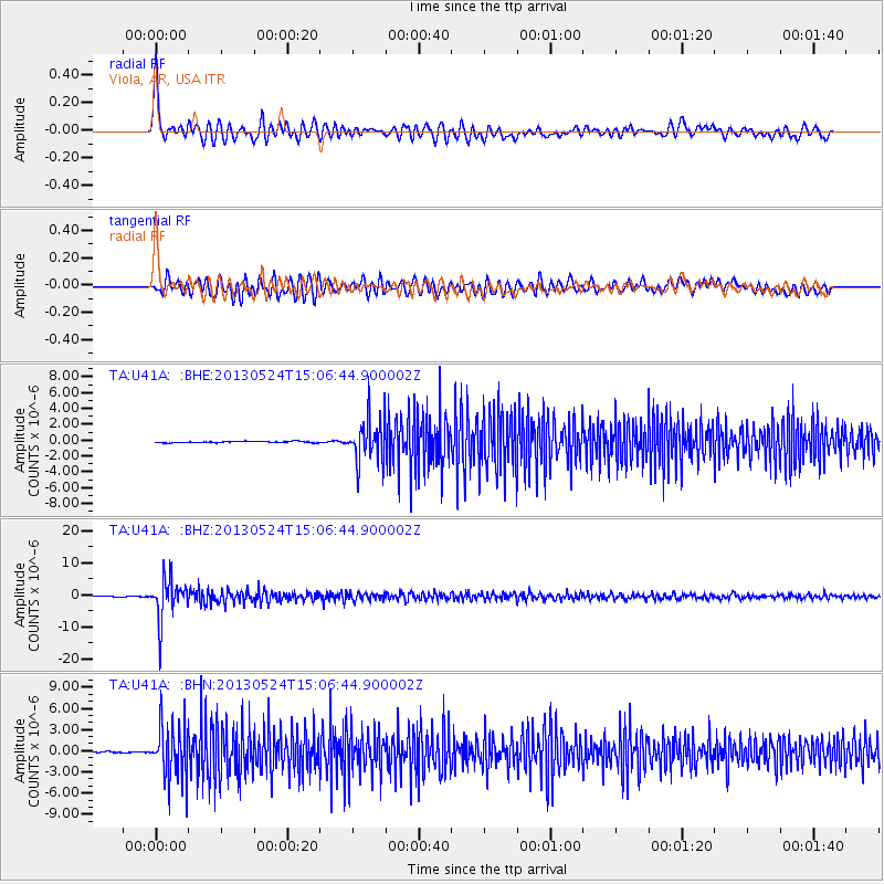
| Radial Match: |
81.64141 % |
| Radial Bump: |
400 |
| Transverse Match: |
70.67035 % |
| Transverse Bump: |
400 |
| SOD ConfigId: |
512894 |
| Insert Time: |
2013-09-14 19:39:00.464 +0000 |
| GWidth: |
2.5 |
| Max Bumps: |
400 |
| Tol: |
0.001 |
|
Signal To Noise
| Channel | StoN | STA | LTA |
| TA:U41A: :BHZ:20130524T15:06:44.900002Z | 51.473373 | 6.4916844E-6 | 1.2611733E-7 |
| TA:U41A: :BHN:20130524T15:06:44.900002Z | 33.14153 | 3.7536488E-6 | 1.1326118E-7 |
| TA:U41A: :BHE:20130524T15:06:44.900002Z | 30.006008 | 2.600725E-6 | 8.6673474E-8 |
| Arrivals |
| Ps | 5.3 SECOND |
| PpPs | 16 SECOND |
| PsPs/PpSs | 22 SECOND |


