You are here: Home > Network List > TA - USArray Transportable Network (new EarthScope stations) Stations List
> Station U47A Clarksville, TN, USA > Earthquake Result Viewer
U47A Clarksville, TN, USA - Earthquake Result Viewer

| Earthquake location: |
Sea Of Okhotsk |
| Earthquake latitude/longitude: |
52.2/151.4 |
| Earthquake time(UTC): |
2013/05/24 (144) 14:56:31 GMT |
| Earthquake Depth: |
624 km |
| Earthquake Magnitude: |
6.7 MW, 6.7 MB, 6.7 MW |
| Earthquake Catalog/Contributor: |
NEIC PDE/NEIC PDE-W |
|
| Network: |
TA USArray Transportable Network (new EarthScope stations) |
| Station: |
U47A Clarksville, TN, USA |
| Lat/Lon: |
36.44 N/87.29 W |
| Elevation: |
145 m |
|
| Distance: |
77.9 deg |
| Az: |
44.814 deg |
| Baz: |
327.484 deg |
| Ray Param: |
0.0479905 |
| Estimated Moho Depth: |
49.5 km |
| Estimated Crust Vp/Vs: |
1.77 |
| Assumed Crust Vp: |
6.444 km/s |
| Estimated Crust Vs: |
3.641 km/s |
| Estimated Crust Poisson's Ratio: |
0.27 |
|
| Radial Match: |
92.291985 % |
| Radial Bump: |
400 |
| Transverse Match: |
87.31409 % |
| Transverse Bump: |
400 |
| SOD ConfigId: |
512894 |
| Insert Time: |
2013-09-14 19:39:05.889 +0000 |
| GWidth: |
2.5 |
| Max Bumps: |
400 |
| Tol: |
0.001 |
|
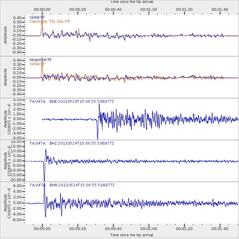
Signal To Noise
| Channel | StoN | STA | LTA |
| TA:U47A: :BHZ:20130524T15:06:55.598977Z | 77.515076 | 6.755533E-6 | 8.7151214E-8 |
| TA:U47A: :BHN:20130524T15:06:55.598977Z | 20.540953 | 2.2864033E-6 | 1.11309504E-7 |
| TA:U47A: :BHE:20130524T15:06:55.598977Z | 22.9261 | 1.4403234E-6 | 6.282462E-8 |
| Arrivals |
| Ps | 6.1 SECOND |
| PpPs | 21 SECOND |
| PsPs/PpSs | 27 SECOND |


