You are here: Home > Network List > TA - USArray Transportable Network (new EarthScope stations) Stations List
> Station U52A Thorn Hill, TN, USA > Earthquake Result Viewer
U52A Thorn Hill, TN, USA - Earthquake Result Viewer
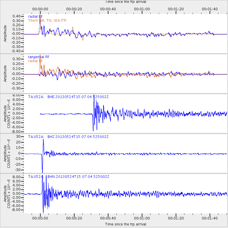
| Earthquake location: |
Sea Of Okhotsk |
| Earthquake latitude/longitude: |
52.2/151.4 |
| Earthquake time(UTC): |
2013/05/24 (144) 14:56:31 GMT |
| Earthquake Depth: |
624 km |
| Earthquake Magnitude: |
6.7 MW, 6.7 MB, 6.7 MW |
| Earthquake Catalog/Contributor: |
NEIC PDE/NEIC PDE-W |
|
| Network: |
TA USArray Transportable Network (new EarthScope stations) |
| Station: |
U52A Thorn Hill, TN, USA |
| Lat/Lon: |
36.39 N/83.37 W |
| Elevation: |
510 m |
|
| Distance: |
79.6 deg |
| Az: |
42.094 deg |
| Baz: |
329.274 deg |
| Ray Param: |
0.046862546 |
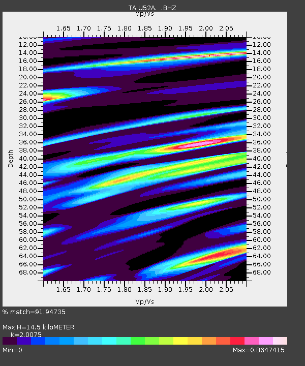
| Estimated Moho Depth: |
14.5 km |
| Estimated Crust Vp/Vs: |
2.01 |
| Assumed Crust Vp: |
6.476 km/s |
| Estimated Crust Vs: |
3.226 km/s |
| Estimated Crust Poisson's Ratio: |
0.33 |
|
| Radial Match: |
91.94735 % |
| Radial Bump: |
400 |
| Transverse Match: |
89.92259 % |
| Transverse Bump: |
400 |
| SOD ConfigId: |
512894 |
| Insert Time: |
2013-09-14 19:39:20.379 +0000 |
| GWidth: |
2.5 |
| Max Bumps: |
400 |
| Tol: |
0.001 |
|
Signal To Noise
| Channel | StoN | STA | LTA |
| TA:U52A: :BHZ:20130524T15:07:04.525002Z | 65.4341 | 9.968001E-6 | 1.523365E-7 |
| TA:U52A: :BHN:20130524T15:07:04.525002Z | 31.97083 | 4.074138E-6 | 1.2743297E-7 |
| TA:U52A: :BHE:20130524T15:07:04.525002Z | 34.51657 | 3.1901386E-6 | 9.242339E-8 |
| Arrivals |
| Ps | 2.3 SECOND |
| PpPs | 6.6 SECOND |
| PsPs/PpSs | 8.9 SECOND |


