You are here: Home > Network List > TA - USArray Transportable Network (new EarthScope stations) Stations List
> Station V46A Holladay, TN, USA > Earthquake Result Viewer
V46A Holladay, TN, USA - Earthquake Result Viewer
| Earthquake location: |
Sea Of Okhotsk |
| Earthquake latitude/longitude: |
52.2/151.4 |
| Earthquake time(UTC): |
2013/05/24 (144) 14:56:31 GMT |
| Earthquake Depth: |
624 km |
| Earthquake Magnitude: |
6.7 MW, 6.7 MB, 6.7 MW |
| Earthquake Catalog/Contributor: |
NEIC PDE/NEIC PDE-W |
|
| Network: |
TA USArray Transportable Network (new EarthScope stations) |
| Station: |
V46A Holladay, TN, USA |
| Lat/Lon: |
35.80 N/88.12 W |
| Elevation: |
162 m |
|
| Distance: |
78.1 deg |
| Az: |
45.744 deg |
| Baz: |
327.19 deg |
| Ray Param: |
0.04787525 |
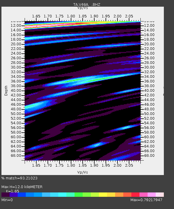
| Estimated Moho Depth: |
12.0 km |
| Estimated Crust Vp/Vs: |
1.65 |
| Assumed Crust Vp: |
6.38 km/s |
| Estimated Crust Vs: |
3.867 km/s |
| Estimated Crust Poisson's Ratio: |
0.21 |
|
| Radial Match: |
93.21023 % |
| Radial Bump: |
400 |
| Transverse Match: |
83.01723 % |
| Transverse Bump: |
400 |
| SOD ConfigId: |
512894 |
| Insert Time: |
2013-09-14 19:39:44.930 +0000 |
| GWidth: |
2.5 |
| Max Bumps: |
400 |
| Tol: |
0.001 |
|

Signal To Noise
| Channel | StoN | STA | LTA |
| TA:V46A: :BHZ:20130524T15:06:56.525002Z | 55.75944 | 6.3783314E-6 | 1.1439016E-7 |
| TA:V46A: :BHN:20130524T15:06:56.525002Z | 17.175266 | 1.6029852E-6 | 9.3331025E-8 |
| TA:V46A: :BHE:20130524T15:06:56.525002Z | 17.6985 | 1.2036172E-6 | 6.800674E-8 |
| Arrivals |
| Ps | 1.3 SECOND |
| PpPs | 4.8 SECOND |
| PsPs/PpSs | 6.1 SECOND |


