You are here: Home > Network List > TA - USArray Transportable Network (new EarthScope stations) Stations List
> Station V48A Smith Brothers Farm, Spring Hill, TN, USA > Earthquake Result Viewer
V48A Smith Brothers Farm, Spring Hill, TN, USA - Earthquake Result Viewer
| Earthquake location: |
Sea Of Okhotsk |
| Earthquake latitude/longitude: |
52.2/151.4 |
| Earthquake time(UTC): |
2013/05/24 (144) 14:56:31 GMT |
| Earthquake Depth: |
624 km |
| Earthquake Magnitude: |
6.7 MW, 6.7 MB, 6.7 MW |
| Earthquake Catalog/Contributor: |
NEIC PDE/NEIC PDE-W |
|
| Network: |
TA USArray Transportable Network (new EarthScope stations) |
| Station: |
V48A Smith Brothers Farm, Spring Hill, TN, USA |
| Lat/Lon: |
35.74 N/86.82 W |
| Elevation: |
278 m |
|
| Distance: |
78.7 deg |
| Az: |
44.87 deg |
| Baz: |
327.769 deg |
| Ray Param: |
0.047463447 |
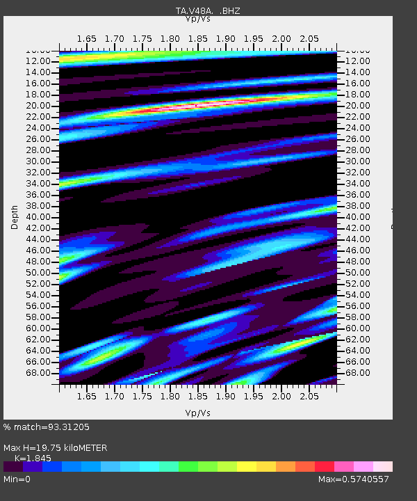
| Estimated Moho Depth: |
19.75 km |
| Estimated Crust Vp/Vs: |
1.85 |
| Assumed Crust Vp: |
6.476 km/s |
| Estimated Crust Vs: |
3.51 km/s |
| Estimated Crust Poisson's Ratio: |
0.29 |
|
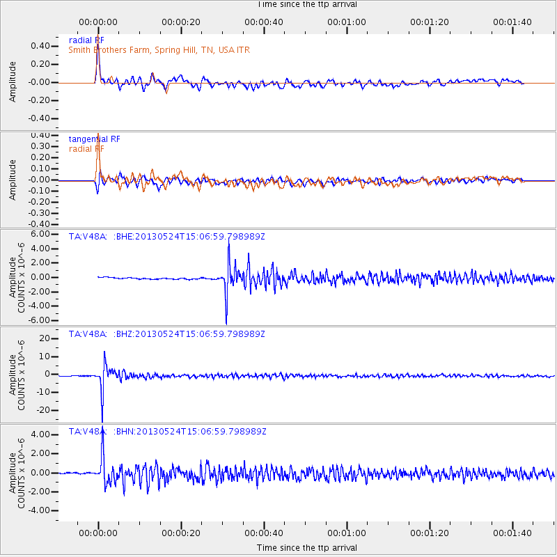
| Radial Match: |
93.31205 % |
| Radial Bump: |
400 |
| Transverse Match: |
86.53495 % |
| Transverse Bump: |
400 |
| SOD ConfigId: |
512894 |
| Insert Time: |
2013-09-14 19:39:49.907 +0000 |
| GWidth: |
2.5 |
| Max Bumps: |
400 |
| Tol: |
0.001 |
|
Signal To Noise
| Channel | StoN | STA | LTA |
| TA:V48A: :BHZ:20130524T15:06:59.798989Z | 64.63122 | 7.181194E-6 | 1.111103E-7 |
| TA:V48A: :BHN:20130524T15:06:59.798989Z | 11.170831 | 1.4937007E-6 | 1.3371438E-7 |
| TA:V48A: :BHE:20130524T15:06:59.798989Z | 18.893208 | 2.0182579E-6 | 1.0682453E-7 |
| Arrivals |
| Ps | 2.6 SECOND |
| PpPs | 8.5 SECOND |
| PsPs/PpSs | 11 SECOND |


