You are here: Home > Network List > TA - USArray Transportable Network (new EarthScope stations) Stations List
> Station V50A Pikevile, TN, USA > Earthquake Result Viewer
V50A Pikevile, TN, USA - Earthquake Result Viewer
| Earthquake location: |
Sea Of Okhotsk |
| Earthquake latitude/longitude: |
52.2/151.4 |
| Earthquake time(UTC): |
2013/05/24 (144) 14:56:31 GMT |
| Earthquake Depth: |
624 km |
| Earthquake Magnitude: |
6.7 MW, 6.7 MB, 6.7 MW |
| Earthquake Catalog/Contributor: |
NEIC PDE/NEIC PDE-W |
|
| Network: |
TA USArray Transportable Network (new EarthScope stations) |
| Station: |
V50A Pikevile, TN, USA |
| Lat/Lon: |
35.67 N/85.10 W |
| Elevation: |
287 m |
|
| Distance: |
79.5 deg |
| Az: |
43.695 deg |
| Baz: |
328.548 deg |
| Ray Param: |
0.046934117 |
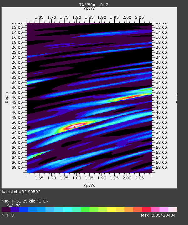
| Estimated Moho Depth: |
51.25 km |
| Estimated Crust Vp/Vs: |
1.79 |
| Assumed Crust Vp: |
6.35 km/s |
| Estimated Crust Vs: |
3.547 km/s |
| Estimated Crust Poisson's Ratio: |
0.27 |
|
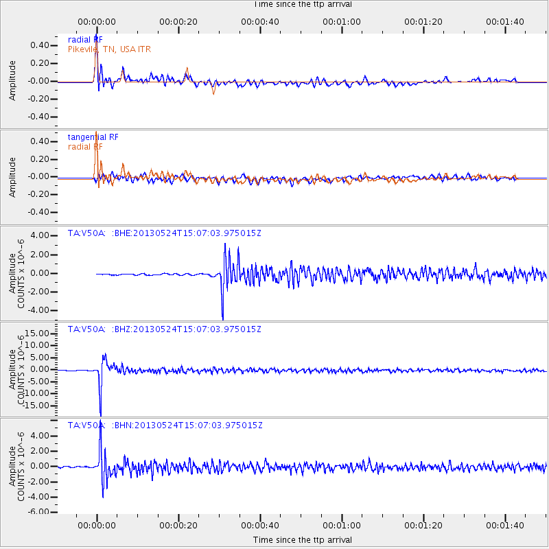
| Radial Match: |
92.99502 % |
| Radial Bump: |
400 |
| Transverse Match: |
84.06953 % |
| Transverse Bump: |
400 |
| SOD ConfigId: |
512894 |
| Insert Time: |
2013-09-14 19:39:56.254 +0000 |
| GWidth: |
2.5 |
| Max Bumps: |
400 |
| Tol: |
0.001 |
|
Signal To Noise
| Channel | StoN | STA | LTA |
| TA:V50A: :BHZ:20130524T15:07:03.975015Z | 35.133503 | 5.388969E-6 | 1.5338547E-7 |
| TA:V50A: :BHN:20130524T15:07:03.975015Z | 24.460617 | 1.9509844E-6 | 7.9760234E-8 |
| TA:V50A: :BHE:20130524T15:07:03.975015Z | 25.346294 | 1.7281783E-6 | 6.818268E-8 |
| Arrivals |
| Ps | 6.5 SECOND |
| PpPs | 22 SECOND |
| PsPs/PpSs | 28 SECOND |


