You are here: Home > Network List > TA - USArray Transportable Network (new EarthScope stations) Stations List
> Station V61A Roper, NC, USA > Earthquake Result Viewer
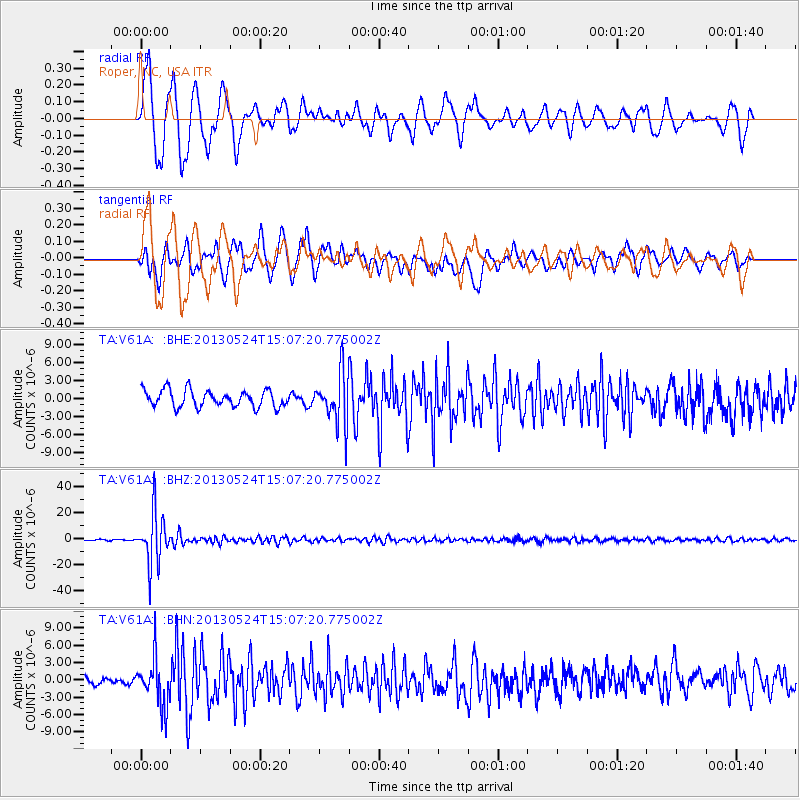
V61A Roper, NC, USA - Earthquake Result Viewer
*The percent match for this event was below the threshold and hence no stack was calculated.
| Earthquake location: |
Sea Of Okhotsk |
| Earthquake latitude/longitude: |
52.2/151.4 |
| Earthquake time(UTC): |
2013/05/24 (144) 14:56:31 GMT |
| Earthquake Depth: |
624 km |
| Earthquake Magnitude: |
6.7 MW, 6.7 MB, 6.7 MW |
| Earthquake Catalog/Contributor: |
NEIC PDE/NEIC PDE-W |
|
| Network: |
TA USArray Transportable Network (new EarthScope stations) |
| Station: |
V61A Roper, NC, USA |
| Lat/Lon: |
35.79 N/76.58 W |
| Elevation: |
4.0 m |
|
| Distance: |
82.8 deg |
| Az: |
37.528 deg |
| Baz: |
332.562 deg |
| Ray Param: |
$rayparam |
*The percent match for this event was below the threshold and hence was not used in the summary stack. |
|
| Radial Match: |
87.04273 % |
| Radial Bump: |
400 |
| Transverse Match: |
72.34945 % |
| Transverse Bump: |
400 |
| SOD ConfigId: |
512894 |
| Insert Time: |
2013-09-14 19:40:26.654 +0000 |
| GWidth: |
2.5 |
| Max Bumps: |
400 |
| Tol: |
0.001 |
|
Signal To Noise
| Channel | StoN | STA | LTA |
| TA:V61A: :BHZ:20130524T15:07:20.775002Z | 34.00848 | 1.970291E-5 | 5.7935284E-7 |
| TA:V61A: :BHN:20130524T15:07:20.775002Z | 4.896373 | 4.1783987E-6 | 8.533661E-7 |
| TA:V61A: :BHE:20130524T15:07:20.775002Z | 3.0454195 | 4.2359557E-6 | 1.3909269E-6 |
| Arrivals |
| Ps | |
| PpPs | |
| PsPs/PpSs | |


