You are here: Home > Network List > TA - USArray Transportable Network (new EarthScope stations) Stations List
> Station W58A Raeford, NC, USA > Earthquake Result Viewer
W58A Raeford, NC, USA - Earthquake Result Viewer
| Earthquake location: |
Sea Of Okhotsk |
| Earthquake latitude/longitude: |
52.2/151.4 |
| Earthquake time(UTC): |
2013/05/24 (144) 14:56:31 GMT |
| Earthquake Depth: |
624 km |
| Earthquake Magnitude: |
6.7 MW, 6.7 MB, 6.7 MW |
| Earthquake Catalog/Contributor: |
NEIC PDE/NEIC PDE-W |
|
| Network: |
TA USArray Transportable Network (new EarthScope stations) |
| Station: |
W58A Raeford, NC, USA |
| Lat/Lon: |
35.02 N/79.23 W |
| Elevation: |
84 m |
|
| Distance: |
82.5 deg |
| Az: |
39.822 deg |
| Baz: |
331.323 deg |
| Ray Param: |
0.044945102 |
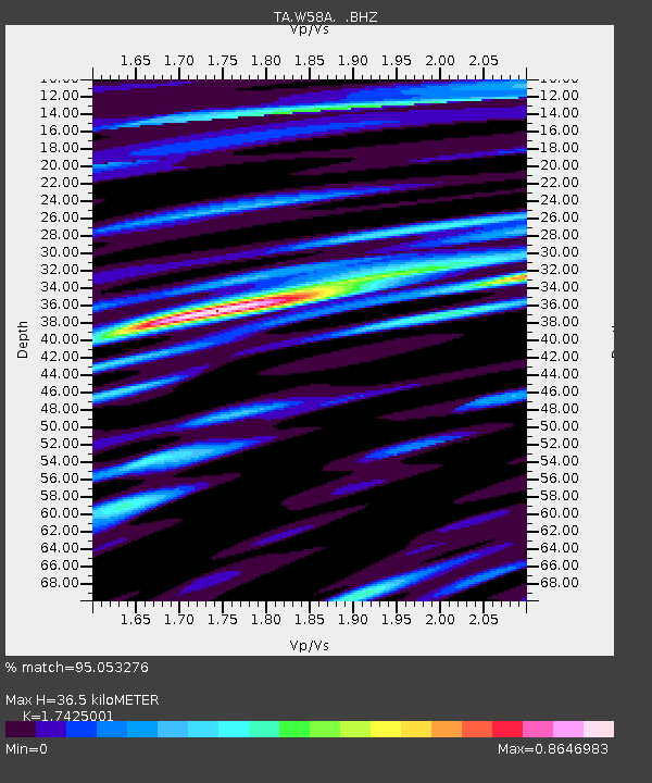
| Estimated Moho Depth: |
36.5 km |
| Estimated Crust Vp/Vs: |
1.74 |
| Assumed Crust Vp: |
6.565 km/s |
| Estimated Crust Vs: |
3.767 km/s |
| Estimated Crust Poisson's Ratio: |
0.25 |
|
| Radial Match: |
95.053276 % |
| Radial Bump: |
400 |
| Transverse Match: |
86.99031 % |
| Transverse Bump: |
400 |
| SOD ConfigId: |
512894 |
| Insert Time: |
2013-09-14 19:41:09.217 +0000 |
| GWidth: |
2.5 |
| Max Bumps: |
400 |
| Tol: |
0.001 |
|

Signal To Noise
| Channel | StoN | STA | LTA |
| TA:W58A: :BHZ:20130524T15:07:19.074014Z | 75.6185 | 1.2526603E-5 | 1.6565528E-7 |
| TA:W58A: :BHN:20130524T15:07:19.074014Z | 50.982178 | 6.9569423E-6 | 1.3645833E-7 |
| TA:W58A: :BHE:20130524T15:07:19.074014Z | 46.471405 | 7.372732E-6 | 1.5865093E-7 |
| Arrivals |
| Ps | 4.2 SECOND |
| PpPs | 15 SECOND |
| PsPs/PpSs | 19 SECOND |


