You are here: Home > Network List > TA - USArray Transportable Network (new EarthScope stations) Stations List
> Station X51A Calhoun, GA, USA > Earthquake Result Viewer
X51A Calhoun, GA, USA - Earthquake Result Viewer

| Earthquake location: |
Sea Of Okhotsk |
| Earthquake latitude/longitude: |
52.2/151.4 |
| Earthquake time(UTC): |
2013/05/24 (144) 14:56:31 GMT |
| Earthquake Depth: |
624 km |
| Earthquake Magnitude: |
6.7 MW, 6.7 MB, 6.7 MW |
| Earthquake Catalog/Contributor: |
NEIC PDE/NEIC PDE-W |
|
| Network: |
TA USArray Transportable Network (new EarthScope stations) |
| Station: |
X51A Calhoun, GA, USA |
| Lat/Lon: |
34.57 N/84.86 W |
| Elevation: |
214 m |
|
| Distance: |
80.6 deg |
| Az: |
44.105 deg |
| Baz: |
328.758 deg |
| Ray Param: |
0.046241473 |
| Estimated Moho Depth: |
36.5 km |
| Estimated Crust Vp/Vs: |
2.05 |
| Assumed Crust Vp: |
6.35 km/s |
| Estimated Crust Vs: |
3.094 km/s |
| Estimated Crust Poisson's Ratio: |
0.34 |
|
| Radial Match: |
87.326385 % |
| Radial Bump: |
400 |
| Transverse Match: |
81.033905 % |
| Transverse Bump: |
400 |
| SOD ConfigId: |
512894 |
| Insert Time: |
2013-09-14 19:41:43.007 +0000 |
| GWidth: |
2.5 |
| Max Bumps: |
400 |
| Tol: |
0.001 |
|
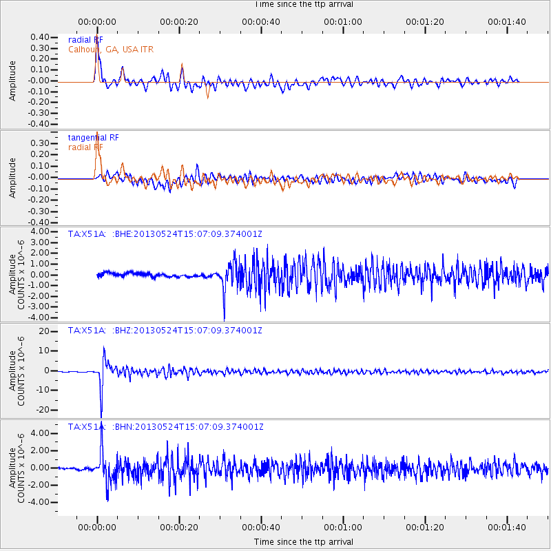
Signal To Noise
| Channel | StoN | STA | LTA |
| TA:X51A: :BHZ:20130524T15:07:09.374001Z | 51.471184 | 7.0286173E-6 | 1.3655442E-7 |
| TA:X51A: :BHN:20130524T15:07:09.374001Z | 14.597075 | 1.8538219E-6 | 1.2699954E-7 |
| TA:X51A: :BHE:20130524T15:07:09.374001Z | 7.578923 | 1.2685023E-6 | 1.6737236E-7 |
| Arrivals |
| Ps | 6.2 SECOND |
| PpPs | 17 SECOND |
| PsPs/PpSs | 23 SECOND |


