You are here: Home > Network List > TA - USArray Transportable Network (new EarthScope stations) Stations List
> Station X54A Belton, SC, USA > Earthquake Result Viewer
X54A Belton, SC, USA - Earthquake Result Viewer

| Earthquake location: |
Sea Of Okhotsk |
| Earthquake latitude/longitude: |
52.2/151.4 |
| Earthquake time(UTC): |
2013/05/24 (144) 14:56:31 GMT |
| Earthquake Depth: |
624 km |
| Earthquake Magnitude: |
6.7 MW, 6.7 MB, 6.7 MW |
| Earthquake Catalog/Contributor: |
NEIC PDE/NEIC PDE-W |
|
| Network: |
TA USArray Transportable Network (new EarthScope stations) |
| Station: |
X54A Belton, SC, USA |
| Lat/Lon: |
34.55 N/82.37 W |
| Elevation: |
213 m |
|
| Distance: |
81.6 deg |
| Az: |
42.331 deg |
| Baz: |
329.886 deg |
| Ray Param: |
0.045530677 |
| Estimated Moho Depth: |
41.75 km |
| Estimated Crust Vp/Vs: |
1.79 |
| Assumed Crust Vp: |
6.35 km/s |
| Estimated Crust Vs: |
3.547 km/s |
| Estimated Crust Poisson's Ratio: |
0.27 |
|
| Radial Match: |
89.44806 % |
| Radial Bump: |
400 |
| Transverse Match: |
77.62163 % |
| Transverse Bump: |
400 |
| SOD ConfigId: |
512894 |
| Insert Time: |
2013-09-14 19:41:48.859 +0000 |
| GWidth: |
2.5 |
| Max Bumps: |
400 |
| Tol: |
0.001 |
|
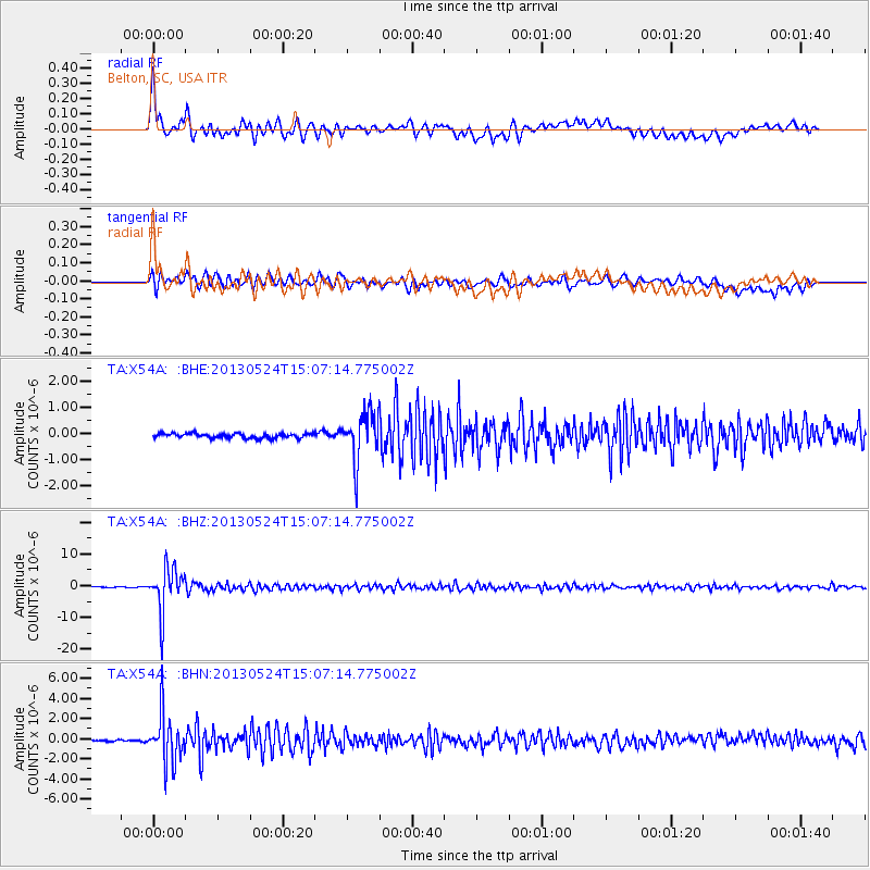
Signal To Noise
| Channel | StoN | STA | LTA |
| TA:X54A: :BHZ:20130524T15:07:14.775002Z | 69.84081 | 6.910636E-6 | 9.894839E-8 |
| TA:X54A: :BHN:20130524T15:07:14.775002Z | 20.4256 | 2.392138E-6 | 1.171147E-7 |
| TA:X54A: :BHE:20130524T15:07:14.775002Z | 10.130611 | 9.0282253E-7 | 8.9118274E-8 |
| Arrivals |
| Ps | 5.3 SECOND |
| PpPs | 18 SECOND |
| PsPs/PpSs | 23 SECOND |


