You are here: Home > Network List > TA - USArray Transportable Network (new EarthScope stations) Stations List
> Station Y48A Jasper, AL, USA > Earthquake Result Viewer
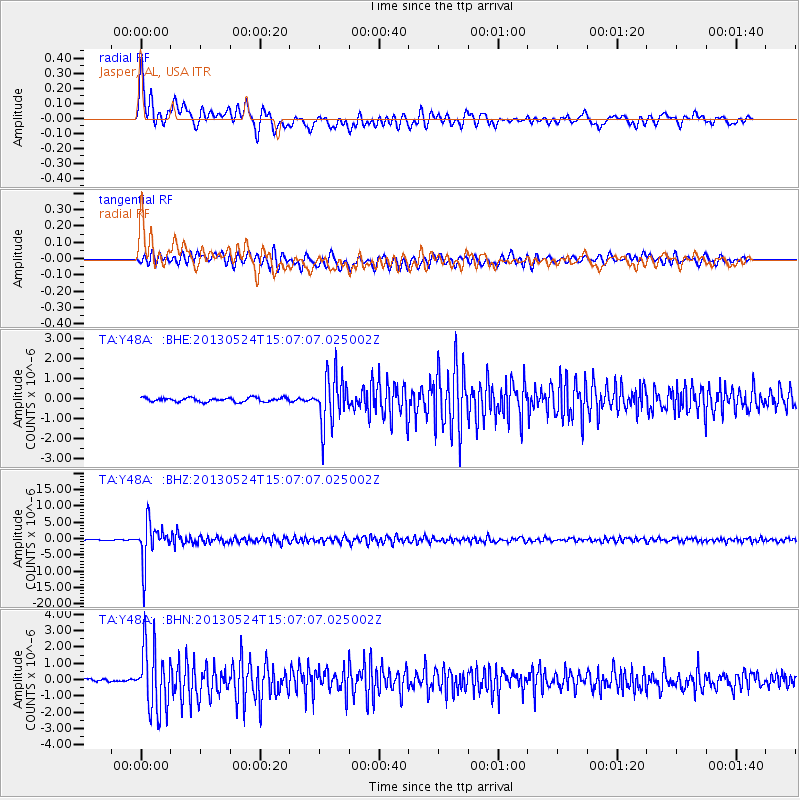
Y48A Jasper, AL, USA - Earthquake Result Viewer
| Earthquake location: |
Sea Of Okhotsk |
| Earthquake latitude/longitude: |
52.2/151.4 |
| Earthquake time(UTC): |
2013/05/24 (144) 14:56:31 GMT |
| Earthquake Depth: |
624 km |
| Earthquake Magnitude: |
6.7 MW, 6.7 MB, 6.7 MW |
| Earthquake Catalog/Contributor: |
NEIC PDE/NEIC PDE-W |
|
| Network: |
TA USArray Transportable Network (new EarthScope stations) |
| Station: |
Y48A Jasper, AL, USA |
| Lat/Lon: |
33.91 N/87.17 W |
| Elevation: |
170 m |
|
| Distance: |
80.1 deg |
| Az: |
46.105 deg |
| Baz: |
327.798 deg |
| Ray Param: |
0.04654349 |
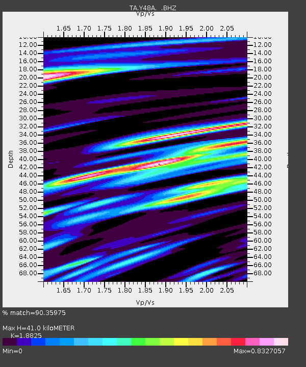
| Estimated Moho Depth: |
41.0 km |
| Estimated Crust Vp/Vs: |
1.88 |
| Assumed Crust Vp: |
6.565 km/s |
| Estimated Crust Vs: |
3.487 km/s |
| Estimated Crust Poisson's Ratio: |
0.30 |
|
| Radial Match: |
90.35975 % |
| Radial Bump: |
400 |
| Transverse Match: |
80.46935 % |
| Transverse Bump: |
400 |
| SOD ConfigId: |
512894 |
| Insert Time: |
2013-09-14 19:42:13.863 +0000 |
| GWidth: |
2.5 |
| Max Bumps: |
400 |
| Tol: |
0.001 |
|
Signal To Noise
| Channel | StoN | STA | LTA |
| TA:Y48A: :BHZ:20130524T15:07:07.025002Z | 57.88929 | 6.154125E-6 | 1.06308526E-7 |
| TA:Y48A: :BHN:20130524T15:07:07.025002Z | 21.004728 | 1.9566203E-6 | 9.315142E-8 |
| TA:Y48A: :BHE:20130524T15:07:07.025002Z | 12.414945 | 1.2593051E-6 | 1.01434615E-7 |
| Arrivals |
| Ps | 5.7 SECOND |
| PpPs | 18 SECOND |
| PsPs/PpSs | 23 SECOND |


