You are here: Home > Network List > TA - USArray Transportable Network (new EarthScope stations) Stations List
> Station Y51A Rockmart, GA, USA > Earthquake Result Viewer
Y51A Rockmart, GA, USA - Earthquake Result Viewer
| Earthquake location: |
Sea Of Okhotsk |
| Earthquake latitude/longitude: |
52.2/151.4 |
| Earthquake time(UTC): |
2013/05/24 (144) 14:56:31 GMT |
| Earthquake Depth: |
624 km |
| Earthquake Magnitude: |
6.7 MW, 6.7 MB, 6.7 MW |
| Earthquake Catalog/Contributor: |
NEIC PDE/NEIC PDE-W |
|
| Network: |
TA USArray Transportable Network (new EarthScope stations) |
| Station: |
Y51A Rockmart, GA, USA |
| Lat/Lon: |
33.90 N/85.06 W |
| Elevation: |
380 m |
|
| Distance: |
81.1 deg |
| Az: |
44.603 deg |
| Baz: |
328.722 deg |
| Ray Param: |
0.045916963 |
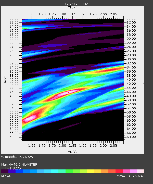
| Estimated Moho Depth: |
46.0 km |
| Estimated Crust Vp/Vs: |
1.83 |
| Assumed Crust Vp: |
6.719 km/s |
| Estimated Crust Vs: |
3.677 km/s |
| Estimated Crust Poisson's Ratio: |
0.29 |
|
| Radial Match: |
85.76925 % |
| Radial Bump: |
400 |
| Transverse Match: |
69.10319 % |
| Transverse Bump: |
400 |
| SOD ConfigId: |
512894 |
| Insert Time: |
2013-09-14 19:42:19.698 +0000 |
| GWidth: |
2.5 |
| Max Bumps: |
400 |
| Tol: |
0.001 |
|
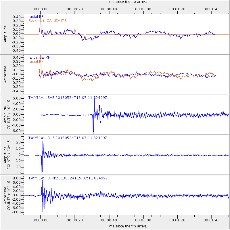
Signal To Noise
| Channel | StoN | STA | LTA |
| TA:Y51A: :BHZ:20130524T15:07:11.82499Z | 69.48565 | 9.103383E-6 | 1.3101098E-7 |
| TA:Y51A: :BHN:20130524T15:07:11.82499Z | 14.91184 | 3.1689367E-6 | 2.1251144E-7 |
| TA:Y51A: :BHE:20130524T15:07:11.82499Z | 17.007195 | 2.4300787E-6 | 1.4288534E-7 |
| Arrivals |
| Ps | 5.8 SECOND |
| PpPs | 19 SECOND |
| PsPs/PpSs | 25 SECOND |


