You are here: Home > Network List > TA - USArray Transportable Network (new EarthScope stations) Stations List
> Station Z54A Sparta, GA, USA > Earthquake Result Viewer
Z54A Sparta, GA, USA - Earthquake Result Viewer
| Earthquake location: |
Sea Of Okhotsk |
| Earthquake latitude/longitude: |
52.2/151.4 |
| Earthquake time(UTC): |
2013/05/24 (144) 14:56:31 GMT |
| Earthquake Depth: |
624 km |
| Earthquake Magnitude: |
6.7 MW, 6.7 MB, 6.7 MW |
| Earthquake Catalog/Contributor: |
NEIC PDE/NEIC PDE-W |
|
| Network: |
TA USArray Transportable Network (new EarthScope stations) |
| Station: |
Z54A Sparta, GA, USA |
| Lat/Lon: |
33.24 N/82.84 W |
| Elevation: |
134 m |
|
| Distance: |
82.6 deg |
| Az: |
43.334 deg |
| Baz: |
329.764 deg |
| Ray Param: |
0.044892184 |
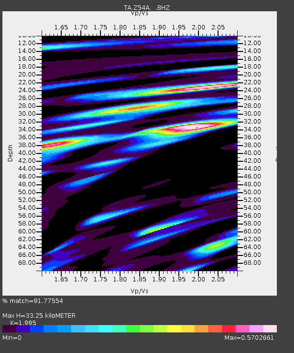
| Estimated Moho Depth: |
33.25 km |
| Estimated Crust Vp/Vs: |
2.00 |
| Assumed Crust Vp: |
6.565 km/s |
| Estimated Crust Vs: |
3.29 km/s |
| Estimated Crust Poisson's Ratio: |
0.33 |
|
| Radial Match: |
91.77554 % |
| Radial Bump: |
400 |
| Transverse Match: |
87.74533 % |
| Transverse Bump: |
400 |
| SOD ConfigId: |
512894 |
| Insert Time: |
2013-09-14 19:43:02.129 +0000 |
| GWidth: |
2.5 |
| Max Bumps: |
400 |
| Tol: |
0.001 |
|
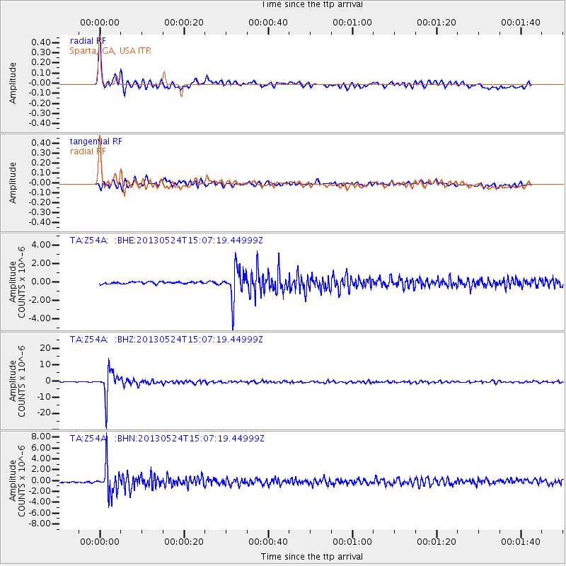
Signal To Noise
| Channel | StoN | STA | LTA |
| TA:Z54A: :BHZ:20130524T15:07:19.44999Z | 66.91382 | 8.286756E-6 | 1.2384223E-7 |
| TA:Z54A: :BHN:20130524T15:07:19.44999Z | 14.185505 | 2.6544965E-6 | 1.8712738E-7 |
| TA:Z54A: :BHE:20130524T15:07:19.44999Z | 17.33928 | 1.7212444E-6 | 9.926851E-8 |
| Arrivals |
| Ps | 5.2 SECOND |
| PpPs | 15 SECOND |
| PsPs/PpSs | 20 SECOND |


