You are here: Home > Network List > TA - USArray Transportable Network (new EarthScope stations) Stations List
> Station Z55A Blythe, GA, USA > Earthquake Result Viewer
Z55A Blythe, GA, USA - Earthquake Result Viewer
| Earthquake location: |
Sea Of Okhotsk |
| Earthquake latitude/longitude: |
52.2/151.4 |
| Earthquake time(UTC): |
2013/05/24 (144) 14:56:31 GMT |
| Earthquake Depth: |
624 km |
| Earthquake Magnitude: |
6.7 MW, 6.7 MB, 6.7 MW |
| Earthquake Catalog/Contributor: |
NEIC PDE/NEIC PDE-W |
|
| Network: |
TA USArray Transportable Network (new EarthScope stations) |
| Station: |
Z55A Blythe, GA, USA |
| Lat/Lon: |
33.22 N/82.14 W |
| Elevation: |
100 m |
|
| Distance: |
82.9 deg |
| Az: |
42.825 deg |
| Baz: |
330.085 deg |
| Ray Param: |
0.044681124 |
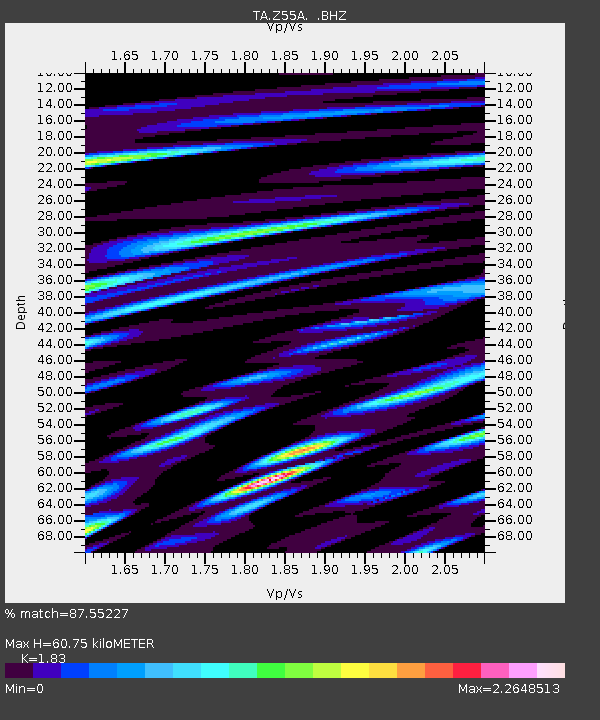
| Estimated Moho Depth: |
60.75 km |
| Estimated Crust Vp/Vs: |
1.83 |
| Assumed Crust Vp: |
6.565 km/s |
| Estimated Crust Vs: |
3.587 km/s |
| Estimated Crust Poisson's Ratio: |
0.29 |
|
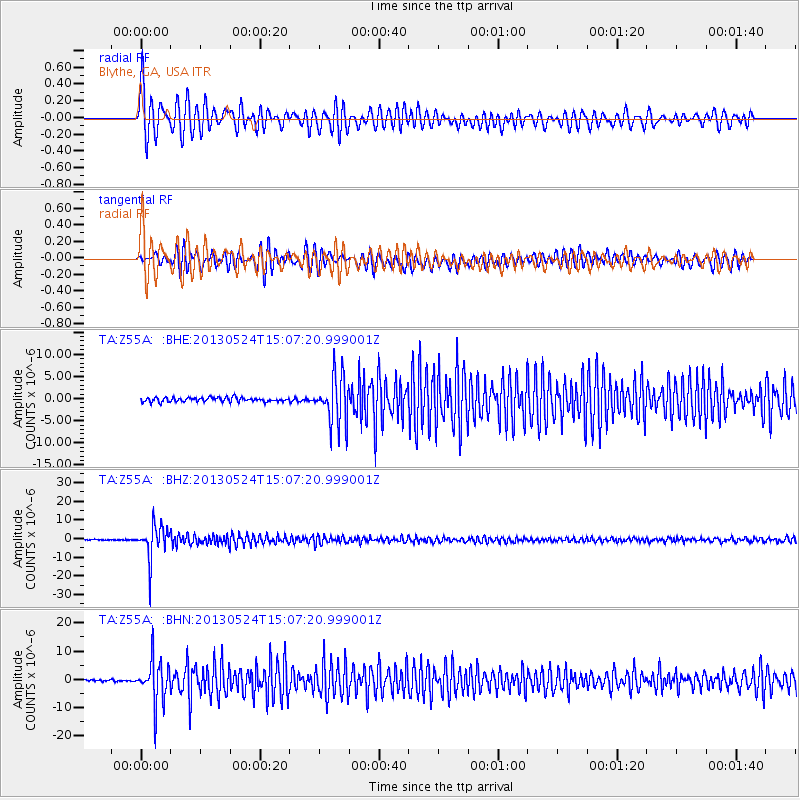
| Radial Match: |
87.55227 % |
| Radial Bump: |
400 |
| Transverse Match: |
82.85005 % |
| Transverse Bump: |
400 |
| SOD ConfigId: |
512894 |
| Insert Time: |
2013-09-14 19:43:07.449 +0000 |
| GWidth: |
2.5 |
| Max Bumps: |
400 |
| Tol: |
0.001 |
|
Signal To Noise
| Channel | StoN | STA | LTA |
| TA:Z55A: :BHZ:20130524T15:07:20.999001Z | 34.031 | 9.074388E-6 | 2.6665066E-7 |
| TA:Z55A: :BHN:20130524T15:07:20.999001Z | 22.555449 | 7.682667E-6 | 3.406125E-7 |
| TA:Z55A: :BHE:20130524T15:07:20.999001Z | 11.51321 | 5.4590205E-6 | 4.7415276E-7 |
| Arrivals |
| Ps | 7.9 SECOND |
| PpPs | 26 SECOND |
| PsPs/PpSs | 33 SECOND |


