You are here: Home > Network List > TA - USArray Transportable Network (new EarthScope stations) Stations List
> Station Z57A Bowman, SC, USA > Earthquake Result Viewer
Z57A Bowman, SC, USA - Earthquake Result Viewer
| Earthquake location: |
Sea Of Okhotsk |
| Earthquake latitude/longitude: |
52.2/151.4 |
| Earthquake time(UTC): |
2013/05/24 (144) 14:56:31 GMT |
| Earthquake Depth: |
624 km |
| Earthquake Magnitude: |
6.7 MW, 6.7 MB, 6.7 MW |
| Earthquake Catalog/Contributor: |
NEIC PDE/NEIC PDE-W |
|
| Network: |
TA USArray Transportable Network (new EarthScope stations) |
| Station: |
Z57A Bowman, SC, USA |
| Lat/Lon: |
33.30 N/80.70 W |
| Elevation: |
81 m |
|
| Distance: |
83.4 deg |
| Az: |
41.737 deg |
| Baz: |
330.736 deg |
| Ray Param: |
0.044324063 |
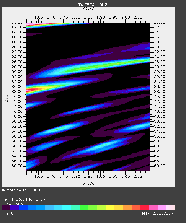
| Estimated Moho Depth: |
10.5 km |
| Estimated Crust Vp/Vs: |
1.61 |
| Assumed Crust Vp: |
6.565 km/s |
| Estimated Crust Vs: |
4.09 km/s |
| Estimated Crust Poisson's Ratio: |
0.18 |
|
| Radial Match: |
87.11089 % |
| Radial Bump: |
400 |
| Transverse Match: |
74.52123 % |
| Transverse Bump: |
400 |
| SOD ConfigId: |
512894 |
| Insert Time: |
2013-09-14 19:43:13.300 +0000 |
| GWidth: |
2.5 |
| Max Bumps: |
400 |
| Tol: |
0.001 |
|

Signal To Noise
| Channel | StoN | STA | LTA |
| TA:Z57A: :BHZ:20130524T15:07:23.600015Z | 41.660553 | 1.0180574E-5 | 2.4436963E-7 |
| TA:Z57A: :BHN:20130524T15:07:23.600015Z | 7.4624796 | 5.329745E-6 | 7.142056E-7 |
| TA:Z57A: :BHE:20130524T15:07:23.600015Z | 5.032022 | 3.647385E-6 | 7.248349E-7 |
| Arrivals |
| Ps | 1.0 SECOND |
| PpPs | 4.1 SECOND |
| PsPs/PpSs | 5.0 SECOND |


