You are here: Home > Network List > US - United States National Seismic Network Stations List
> Station AMTX Amarillo, Texas, USA > Earthquake Result Viewer
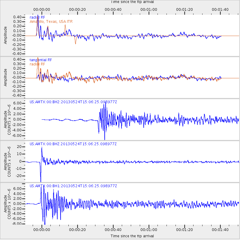
AMTX Amarillo, Texas, USA - Earthquake Result Viewer
*The percent match for this event was below the threshold and hence no stack was calculated.
| Earthquake location: |
Sea Of Okhotsk |
| Earthquake latitude/longitude: |
52.2/151.4 |
| Earthquake time(UTC): |
2013/05/24 (144) 14:56:31 GMT |
| Earthquake Depth: |
624 km |
| Earthquake Magnitude: |
6.7 MW, 6.7 MB, 6.7 MW |
| Earthquake Catalog/Contributor: |
NEIC PDE/NEIC PDE-W |
|
| Network: |
US United States National Seismic Network |
| Station: |
AMTX Amarillo, Texas, USA |
| Lat/Lon: |
34.53 N/101.41 W |
| Elevation: |
1010 m |
|
| Distance: |
72.8 deg |
| Az: |
55.66 deg |
| Baz: |
322.043 deg |
| Ray Param: |
$rayparam |
*The percent match for this event was below the threshold and hence was not used in the summary stack. |
|
| Radial Match: |
86.128654 % |
| Radial Bump: |
400 |
| Transverse Match: |
81.273346 % |
| Transverse Bump: |
400 |
| SOD ConfigId: |
512894 |
| Insert Time: |
2013-09-14 19:44:07.419 +0000 |
| GWidth: |
2.5 |
| Max Bumps: |
400 |
| Tol: |
0.001 |
|
Signal To Noise
| Channel | StoN | STA | LTA |
| US:AMTX:00:BHZ:20130524T15:06:25.098977Z | 34.12666 | 8.223093E-6 | 2.4095803E-7 |
| US:AMTX:00:BH1:20130524T15:06:25.098977Z | 23.949844 | 3.929235E-6 | 1.6406099E-7 |
| US:AMTX:00:BH2:20130524T15:06:25.098977Z | 15.656112 | 3.16255E-6 | 2.0200098E-7 |
| Arrivals |
| Ps | |
| PpPs | |
| PsPs/PpSs | |


