You are here: Home > Network List > US - United States National Seismic Network Stations List
> Station BRAL Brewton, Alabama, USA > Earthquake Result Viewer
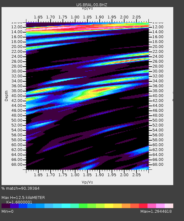
BRAL Brewton, Alabama, USA - Earthquake Result Viewer
| Earthquake location: |
Sea Of Okhotsk |
| Earthquake latitude/longitude: |
52.2/151.4 |
| Earthquake time(UTC): |
2013/05/24 (144) 14:56:31 GMT |
| Earthquake Depth: |
624 km |
| Earthquake Magnitude: |
6.7 MW, 6.7 MB, 6.7 MW |
| Earthquake Catalog/Contributor: |
NEIC PDE/NEIC PDE-W |
|
| Network: |
US United States National Seismic Network |
| Station: |
BRAL Brewton, Alabama, USA |
| Lat/Lon: |
31.01 N/87.06 W |
| Elevation: |
61 m |
|
| Distance: |
82.6 deg |
| Az: |
47.577 deg |
| Baz: |
328.079 deg |
| Ray Param: |
0.044856224 |
| Estimated Moho Depth: |
12.5 km |
| Estimated Crust Vp/Vs: |
1.68 |
| Assumed Crust Vp: |
6.187 km/s |
| Estimated Crust Vs: |
3.683 km/s |
| Estimated Crust Poisson's Ratio: |
0.23 |
|
| Radial Match: |
90.39364 % |
| Radial Bump: |
400 |
| Transverse Match: |
83.482834 % |
| Transverse Bump: |
400 |
| SOD ConfigId: |
512894 |
| Insert Time: |
2013-09-14 19:44:18.648 +0000 |
| GWidth: |
2.5 |
| Max Bumps: |
400 |
| Tol: |
0.001 |
|

Signal To Noise
| Channel | StoN | STA | LTA |
| US:BRAL:00:BHZ:20130524T15:07:19.07499Z | 62.978905 | 1.8037308E-5 | 2.8640238E-7 |
| US:BRAL:00:BH1:20130524T15:07:19.07499Z | 10.095303 | 4.8795105E-6 | 4.8334465E-7 |
| US:BRAL:00:BH2:20130524T15:07:19.07499Z | 4.213152 | 1.9769557E-6 | 4.6923435E-7 |
| Arrivals |
| Ps | 1.4 SECOND |
| PpPs | 5.3 SECOND |
| PsPs/PpSs | 6.7 SECOND |


